I just read the story "कटते हुए वनों का शोकगीत" in The Public Agenda, which draws our attention towards the disturbing trend of reduction in the forest cover of Nepal at the rate of 270 ha/ day, the role of mafia iand Maoists in the Himalayan forests, ten fold increase in the rate of siltation in Kosi in the last 26-27 years. and the sad plight of Ganga. I was amused to note that you have completely ignored the contribution of misplaced structural engineering intervention, massive land use change and deforestation on the Indian side despite the fact that 79 % of the Ganga basin is in India. Hopefully, Ranjit Kumar, the writer of the story will deal with it in his next article. Participating in an group discussion on the internet, Kumar made a submission that "only techonology is not responsible for kosi disaster. Corruption played major roll in the failure of kosi project".
He has missed the role of corruption in the drafting of Kosi project plan and Kosi treaty, intellectual dishonesty of people like Dr K L Rao, Kanwar Sen and Nilendu Sanyal and the failure of Bihar Vidhan Sabha in dealing with vested interests has led to the choice of embankment technique as a "temporary solution". And now "multipurpose" High Dam and Interlinking of Rivers within BIhar as a "permanent solution" for flood/drainage crisis is fraught with grave ecological consequences. The environmental crisis in Kosi region could be deemed one of Asia's biggest environmental disaster. The culprits must be identified and made accountable.
Refusing to learn anything from the drainage crisis in the Kosi region, when govt engineers recommend and promote the same failed and discredited embankment technique for the Baghmati region, it is understandable why sensible engineers like Dr V N Sharma and others get outraged.
On the role of jornalists, when it comes to news reporting on the Kosi river, I read a content analysis of the coverage in Nepal and India and that Indian journalists commit the same kind of error year after year after year. The analysis noted that one gets to see more news on the Kosi barrage under the control and operation by Bihar govt emerging from Nepal-based media houses rather than in the Indian media.
It appears that the hydrocracy of Bihar never informs the Bihar journalists the truth of what is going on at Kosi barrage and embankment fronts of both Kosi, Baghmatiand all the rivers you mention in your news report.
Joining the debate Dr Dinesh Kumar Mishra, a well known river basin expert wrote: "Corruption is an outfall of programmes that were not intended to yield results. When everybody except the so called benificiaries knew that the results cannot be achieved, they thought to make hay while the sun shines by telling lies, whilte lies and what not. When the planning was corrupt, it would only lead to corruption. Someone became Minister at the Center, somebody got national decorations like Padma Bhushan etc and the others were made chairpersons of various committees and so on. One of the senior Congressman had termed Kosi Project as Kamadhenu and Kalpataru. You stand under Kalpataru and ask for anything you would get it or if you ask Kamdhenu for any favour, she is there to fulfill it, he is on record to have said this in Bihar Vidhan Sabha. Those who did not ask for laurels, asked for money and got it. I have a sincere feeling that corruption is a non-issue in such projects, it is a corollary. If one wants to know more, look for 50th and 53rd Report of the Estimates Committee of Bihar Vidhan Sabha (1973) and score of such documents that talk about loot devided by four among engineers, contactors, politicians and bureaucrats. There is a saying in Bangla that a person dug holes in the ground looking for earth worms and he found snakes coming out. Try it, you will find snakes instead of earthworms."
Friday, 25 September 2009
Monday, 3 August 2009
Flood situation worsens in Bihar as another river breaches
Note: According to DAILY FLOOD INFORMATION BULLETIN dated August 2, 2009 brought out by
Flood Management Cell of Water Resources Department of Bihar government "Action (has been)initiated to plug the breach between Bagmati right embankment between 54km. to 55km., (about 6 km. up stream of Kataunjha road bridge on NH-77) under Runnisaidpur block in Sitamarhi distt. Stone boulders are being carried to the site from Dheng and sand filled E.C. bags are being stored to plug the breach. Constant vigil is being kept. The river is flowing above danger level but showing receding trend at Sonakhan, Dubbadhar, Kansar/Chandauli.
As per a letter dated August 2, 2009 of Central Water Commission's Middle Ganga Division-V as of 6 AM, 3rd August, 2009, the water level in Bagmati river would remain be 61 cm above danger mark.
Gopal Krishna
Flood situation worsens in Bihar as another river breaches
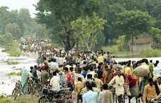
More than four lakh people were reeling under the impact of floods in Bihar with Lakhandei river breaching its embankments at two places, worsening the situation in Sitamarhi and Muzaffarpur districts on Monday. Lakhandei, swelled by swirling flood waters of turbulent Bagmati, breached the embankment in a stretch of over 200 metres near Tilak Tajpur in Sitamarhi district early on Monday, Tirhut Divisional Commissioner S M Raju said.
The water also destroyed its embankments at Baraitha Masjid and another place under Katra block in Muzaffarpur district late last evening. Flood waters submerged over 75 villages under Katra, Gaighat and Bandara blocks in the district, affecting a population of around three lakh, Raju said. Engineers and labourers were working day-and-night to plug the breach in stretches of 50 metres at two places on the embankment of Lakhandehi, he said.
The National Disaster Response Force personnel with boats, life jackets and relief were engaged in providing relief and succour to the affected people. Chief Minister Nitish Kumar, who undertook aerial survey of the flood-hit area in Sitamarhi, announced a compensation package for the displaced persons on the pattern of the one made available to flood-hit victims in Kosi belts in 2008.
A Sitamarhi report quoting official sources said the rescue teams of Sashastra Seema Bal (SSB), Border Security Force (BSF) and NDRF continued the rescue operations on a war-footing. Nearly 15,000 people, rendered homeless due to the breach caused by the Bagmati, have so far taken shelter on the embankment of river for whom make-shift camps were being raised, report said, adding all those inundated by floods have been evacuated to safer places.
The embankment of river Bagmati was overcrowded with displaced persons and the state administration was arranging for their meals, it said. The chief minister, who had already ordered a joint inquiry by the Tirhut Divisional Commission and DIG (Muzaffarpur) into the causes leading to Bagmati breaking its embankment, said each affected family would be provided one quintal of foodgrains and Rs 2,000 as per the calamity relief fund provisions.
About one lakh people have been affected by the breach of Bagmati river. The authorities have so far distributed 3000 plastic sheets, 150 quintals of beaten rice and jaggery among the flood-affected people in Sitamarhi district. The swollen Bagmati also inundated the national Highway Authority of India (NHAI) construction camp at Garha, bringing the construction work to a grind halt in Sitmarhi, official sources said.
According to the state flood control room in Patna, major rivers in north Bihar, including Kosi, Gandak, Burhi Gandak and Bagmati are in the spate following heavy rains in the catchment of these rivers. Water level of Bagmati is above the danger marks at some points along its course in north Bihar, while Gandak is also rising following discharge from Nepal, sources added.
3 August, 2009, Patna
Indian Express
Bagmati waters flood 2 more blocks
MUZAFFARPUR/SITAMARHI: The flood waters from Saturday’s breach of Bagmati river in Bihar submerged two more blocks of Muzaffarpur district adding thousands more to the nearly one lakh people rendered homeless.
This despite the flood fury in Runnisaidpur block in Sitamarhi district being tamed with the breach at Tilak Tajpur village more or less plugged on Sunday.
About 800 labourers, who worked relentlessly for 24-hours, plugged a major portion of the breach by placing boulders and other materials by afternoon. The breach is expected to be totally plugged by Sunday midnight.
CM Nitish Kumar, who along with chief secretary Anup Mukherjee and other senior officials made an arieal survey of the flood-affected villages in Runnisaidpur (Sitamarhi) and Aurai (Muzaffarpur) blocks during the day, held a review meeting on relief and rehabilitation on a school campus in Runnisaidpur. The CM is understood to have issued strict instructions to officials to save villagers and provide relief marooned people.
Nitish said divisional commissioner (Tirhut) S M Raju and DIG B Srinivasan would probe the reasons behind the breach .
Raju said 75 per cent of the breach-plugging work had been completed by afternoon and the remaining work would be completed within the next 12 hours.
Meanwhile, two companies of National Disaster Rescue Force (NDRF) have arrived in Runisaidpur with 32 mechanized boats from Begusarai and Bihta.
Giving this information, NDRF commandant Sukhdev Raj said over 200 marooned villagers have been rescued by his men on Sunday.
He said the situation was not as grim as compared to last year’s deluge.
“During the Kosi deluge last year, the people were unwilling to leave their homes even if they were facing acute problems. This has not been the case here this time,” Commandant Raj said.
Reports said flood victims taking shelter on the embankment made the breach-plugging exercise difficult by looting workers as well as relief materials. The situation was brought under control by deploying police and expediting relief distribution.
The NH-77 was under two feet water at Kauahi village which disrupted movement of vehicles between Muzaffarpur and Sitamarhi.
Sources said when PWD men reached there to put sandbags along the western flank of the highway to stop the flow of water, villagers prevented them from doing so. As it was important to keep the highway open for vehicles to carry relief materials, police and SAP jawans had to intervene to chase away the villagers. Work to stop the flow of water over NH-77 was in progress till the evening, the sources said.
Muzaffarpur DM Vipin Kumar said two teams of National Disaster Rescue Force (NDRF), each comprising 20 personnel, were pressed into service on Sunday for rescue and relief operation among nearly 70,000 flood victims.
Official source said over 50 villages in Sitamarhi and Muzaffarpur districts have been affected by flood waters of the Bagmati. About 30,000 people have taken shelter on embankments and roads near Runnisaidpur. No loss of life has been reported so far.
Priti Nath Jha & Shyam Kishore Singh ,
The Times of India
3 August 2009, 04:42am IST
Flood Management Cell of Water Resources Department of Bihar government "Action (has been)initiated to plug the breach between Bagmati right embankment between 54km. to 55km., (about 6 km. up stream of Kataunjha road bridge on NH-77) under Runnisaidpur block in Sitamarhi distt. Stone boulders are being carried to the site from Dheng and sand filled E.C. bags are being stored to plug the breach. Constant vigil is being kept. The river is flowing above danger level but showing receding trend at Sonakhan, Dubbadhar, Kansar/Chandauli.
As per a letter dated August 2, 2009 of Central Water Commission's Middle Ganga Division-V as of 6 AM, 3rd August, 2009, the water level in Bagmati river would remain be 61 cm above danger mark.
Gopal Krishna
Flood situation worsens in Bihar as another river breaches
More than four lakh people were reeling under the impact of floods in Bihar with Lakhandei river breaching its embankments at two places, worsening the situation in Sitamarhi and Muzaffarpur districts on Monday. Lakhandei, swelled by swirling flood waters of turbulent Bagmati, breached the embankment in a stretch of over 200 metres near Tilak Tajpur in Sitamarhi district early on Monday, Tirhut Divisional Commissioner S M Raju said.
The water also destroyed its embankments at Baraitha Masjid and another place under Katra block in Muzaffarpur district late last evening. Flood waters submerged over 75 villages under Katra, Gaighat and Bandara blocks in the district, affecting a population of around three lakh, Raju said. Engineers and labourers were working day-and-night to plug the breach in stretches of 50 metres at two places on the embankment of Lakhandehi, he said.
The National Disaster Response Force personnel with boats, life jackets and relief were engaged in providing relief and succour to the affected people. Chief Minister Nitish Kumar, who undertook aerial survey of the flood-hit area in Sitamarhi, announced a compensation package for the displaced persons on the pattern of the one made available to flood-hit victims in Kosi belts in 2008.
A Sitamarhi report quoting official sources said the rescue teams of Sashastra Seema Bal (SSB), Border Security Force (BSF) and NDRF continued the rescue operations on a war-footing. Nearly 15,000 people, rendered homeless due to the breach caused by the Bagmati, have so far taken shelter on the embankment of river for whom make-shift camps were being raised, report said, adding all those inundated by floods have been evacuated to safer places.
The embankment of river Bagmati was overcrowded with displaced persons and the state administration was arranging for their meals, it said. The chief minister, who had already ordered a joint inquiry by the Tirhut Divisional Commission and DIG (Muzaffarpur) into the causes leading to Bagmati breaking its embankment, said each affected family would be provided one quintal of foodgrains and Rs 2,000 as per the calamity relief fund provisions.
About one lakh people have been affected by the breach of Bagmati river. The authorities have so far distributed 3000 plastic sheets, 150 quintals of beaten rice and jaggery among the flood-affected people in Sitamarhi district. The swollen Bagmati also inundated the national Highway Authority of India (NHAI) construction camp at Garha, bringing the construction work to a grind halt in Sitmarhi, official sources said.
According to the state flood control room in Patna, major rivers in north Bihar, including Kosi, Gandak, Burhi Gandak and Bagmati are in the spate following heavy rains in the catchment of these rivers. Water level of Bagmati is above the danger marks at some points along its course in north Bihar, while Gandak is also rising following discharge from Nepal, sources added.
3 August, 2009, Patna
Indian Express
Bagmati waters flood 2 more blocks
MUZAFFARPUR/SITAMARHI: The flood waters from Saturday’s breach of Bagmati river in Bihar submerged two more blocks of Muzaffarpur district adding thousands more to the nearly one lakh people rendered homeless.
This despite the flood fury in Runnisaidpur block in Sitamarhi district being tamed with the breach at Tilak Tajpur village more or less plugged on Sunday.
About 800 labourers, who worked relentlessly for 24-hours, plugged a major portion of the breach by placing boulders and other materials by afternoon. The breach is expected to be totally plugged by Sunday midnight.
CM Nitish Kumar, who along with chief secretary Anup Mukherjee and other senior officials made an arieal survey of the flood-affected villages in Runnisaidpur (Sitamarhi) and Aurai (Muzaffarpur) blocks during the day, held a review meeting on relief and rehabilitation on a school campus in Runnisaidpur. The CM is understood to have issued strict instructions to officials to save villagers and provide relief marooned people.
Nitish said divisional commissioner (Tirhut) S M Raju and DIG B Srinivasan would probe the reasons behind the breach .
Raju said 75 per cent of the breach-plugging work had been completed by afternoon and the remaining work would be completed within the next 12 hours.
Meanwhile, two companies of National Disaster Rescue Force (NDRF) have arrived in Runisaidpur with 32 mechanized boats from Begusarai and Bihta.
Giving this information, NDRF commandant Sukhdev Raj said over 200 marooned villagers have been rescued by his men on Sunday.
He said the situation was not as grim as compared to last year’s deluge.
“During the Kosi deluge last year, the people were unwilling to leave their homes even if they were facing acute problems. This has not been the case here this time,” Commandant Raj said.
Reports said flood victims taking shelter on the embankment made the breach-plugging exercise difficult by looting workers as well as relief materials. The situation was brought under control by deploying police and expediting relief distribution.
The NH-77 was under two feet water at Kauahi village which disrupted movement of vehicles between Muzaffarpur and Sitamarhi.
Sources said when PWD men reached there to put sandbags along the western flank of the highway to stop the flow of water, villagers prevented them from doing so. As it was important to keep the highway open for vehicles to carry relief materials, police and SAP jawans had to intervene to chase away the villagers. Work to stop the flow of water over NH-77 was in progress till the evening, the sources said.
Muzaffarpur DM Vipin Kumar said two teams of National Disaster Rescue Force (NDRF), each comprising 20 personnel, were pressed into service on Sunday for rescue and relief operation among nearly 70,000 flood victims.
Official source said over 50 villages in Sitamarhi and Muzaffarpur districts have been affected by flood waters of the Bagmati. About 30,000 people have taken shelter on embankments and roads near Runnisaidpur. No loss of life has been reported so far.
Priti Nath Jha & Shyam Kishore Singh ,
The Times of India
3 August 2009, 04:42am IST
Tuesday, 21 July 2009
Kosi Drainage Crisis, Linking Bihar's Rivers & High Dam
Kosi basin's crisis is one of the most under-rated environmental disasters of South Asia. The Kosi treaty between India and Nepal was/is a historical blunder. It provides the basis for misplaced structural interventions in the Kosi basin. The treaty must be re-visited and must adopt a river basin approach. In India, planning for flood management commenced with the Five Year Plans, particularly with the launching of National Programme of Flood Management in 1954.
Kosi, a major tributary of Ganga of the Himalayan eco system carries the heavy load of sediment therefore, it is a mistake to build any barrage, dams and embankments on it.
Embankments have led to a rise in the level of the river-bed and the consequent elevation of the river above the level of the ground on either side, possible attacks by the river further downstream, and of course the emergence of waterlogging and even flooding in the areas ‘protected’ by the embankments because water cannot drain from those areas into the river.
Floods are natural phenomena and the disaster narrative imposed on predictable floods seems misplaced.
Besides other concerns it must be remembered that dam-and-reservoir project is rarely built exclusively for flood-control. It is generally a multiple purpose project of irrigation, power-generation, flood-control, etc.
Such a Multi-purpose Kosi High Dam project is conflict of purpose ridden because flood-control requires space for flood-waters and irrigation or power-generation would require the dam to be as full as possible. Is the proposed Kosi High dam exclusively meant for flood-control?
Indeed the sane response is that floods should be predicted, anticipated, flood-preparedness and timely evacuation.
By now the evident fallacy of ‘flood control’ is widely acknowledged fact. It is high time flood control structures are done away with in a carefully crafted manner to restore natural flooding regime step-by step in a calibrated way.
These pearls of wisdom reverberated the precincts of India International Centre and Jawaharlal Nehru University, when Dr Dinesh Kumar Mishra visited Delhi recently.
Engineering projects are politically engineered for creating the right context for fishing in the troubles waters. In the aftermath of a ritual assurance given by the Indian and Nepal Water Resources Ministers who "reassured the people of two countries of the safety of the barrage and its flood embankments," a Panel Discussion on "Floods in India: A Recurring Nightmare" at India International Centre (IIC), New Delhi on 17th July 2009 and at Jawaharlal Nehru University (JNU) on 18th July questioned such empty words and assurances which have become routine and are meant to protect the vested interests who are well entrenched in both ruling as well as opposition parties.
Projects like Kosi High Dam and interlinking of rivers are ecologically and socially disastrous, which is being promoted as the panacea of all ills by the central government, Bihar government and APJ Abdul Kalam, former President of India.
The panelists at IIC included G S Purba, Chief Engineer, flood management, River Management Wing, Central Water Commission, Dr Dinesh Kumar Mishra, a voice of sanity on the issue of drainage crisis in South Asia and a veteran civil engineer from IIT-Kharagpur besides Gopal Krishna, Convenor , Water Watch Alliance and Member, Fact Finding Mission on River Kosi. Dr Sudhirendar Sharma , Director, Ecological Foundation introduced the subject of drainage crisis in Kosi basin and the locus standi of the panelists on the issue.
The discussion happened in the backdrop of the recent visit of Pawan Kumar Bansal, Union Minister of Water Resources of India to the Kosi Embankment and barrage in Nepal and the visit of Kalam to Bihar.
Kalam appreciated the Bihar government's decision to inter-link rivers of north Bihar that would help in controlling floods and irrigate the parched lands of south Bihar. Kalam had addressed a joint session of the Bihar state legislatures in 2006 arguing for inter-linking of rivers. Such an approach has already been rejected by the Government of India's National Commission on Integrated Water Resources Management in September 1999.
Earlier, joint press release of India and Nepal dated 12 July, 2009 noted that the purpose of Bansal's visit was to undertake a joint inspection with Minister of Irrigation of Nepal Bal Krishna Khand of the repair works carried out following the breach of Kosi embankment in August 2008. The joint inspection undertaken on 12th July. The inspection team included Minister of Water Resources Bijendra Prasad Yadav of Government of Bihar, Ambassador of India in Nepal, Rakesh Sood, and Umakant Jha, Secretary, Ministry of Irrigation and other senior officials from India and Nepal.
The joint press release issued by India and Nepal government "expressed satisfaction on the timely and satisfactory execution of the Kosi breach closure works. It was a challenging task to revert the river back to barrage by constructing a diversion channel and coffer dam and then to plug the breach. This could be accomplished only through joint cooperation and close coordination between the two governments. They also inspected the repairs undertaken at other vulnerable points along the Kosi embankment and expressed satisfaction. They appreciated the level of the preparedness of the two governments, including large quantities of reserve materials and boulders stacked along the embankment and spurs to meet any exigency during the floods. The two sides have agreed to conduct round the clock patrolling of the embankments during the flood season for any emergent repair works as needed. The Nepalese side assured necessary security."
Unmindful of the havoc caused by embankments, the "Government of India is also providing assistance to Nepal for strengthening of existing and construction of new embankments along Kamala, Bagmati, Lalbakeya, Sunsari, Trijuga, Lakhadehi and Kankai rivers. The detailed project report for strengthening of embankments along Khando river is under consideration. The design and implementation of these schemes is carried out by the agencies of the Government of Nepal."
Although structural engineering measures like embankments and dams have failed, the same is being promoted by the governments in its myopia.
The discussions between the Indian and the Nepali ministers included working on long term solutions of the flood problems caused by Kosi river, which flows about 42 Kms. in Nepal after descending from the mountains and before entering India. The media has reported that these long-term solutions mean Kosi High Dam and Inter-linking od Rivers within Bihar.
Despite 207 recommendations of the National Flood Commission, 1980, at the discussions held at both at IIC and JNU, it was observed that the frequency and intensity of floods has grown in the country over the years primarily because of the increased encroachment of flood plains. It is clear that none of the recommendations have been acted upon. An environmental assessment of Kosi basin is long due to assess the damage done to it by the engineers who acted under tremendous political pressure against even their own engineering wisdom.
While Kosi crisis was declared national calamity by the Prime Minister, the Union Budget indeed aggravated the injustice done to the Kosi affected region, the engineering experiments being undertaken with political consensus of sort has turned citizens of North Bihar and Nepal into guinea pigs. It is such experiments which eventually makes migrants out of Biharis and Nepalis who face humiliation and assault all over the country.
Wednesday, 8 April 2009
Business as usual in Kosi Belt
Refusing to learn anything from past mistakes the embankments are still being built or repaired in Kosi and Bagmati. Kosi flood disaster of 2008 was spread over 5 districts, 35 blocks, 993 villages affecting 33.29 lakh people and spread over an area of 3.68 lakh hectares in India alone which resulted in loss of nearly 600 persons and destruction of 2.37 lakh houses. And nearly 1.5 million people spread over 414 villages trapped between the two embankments of the Kosi which is the route of the normal river flow in a normal year. There is no reason to believe that similar crisis be witnessed this year too.
Around a dozen Lok Sabha seats and 22 Bihar Vidhan Sabha seats fall in the Kosi belt. Congress-RJD-LJP is trying to make large-scale “destruction” as triggered by the Kosi as the main poll issue. It has been reported that Nitish Kumar, the chief minister did not visit those flood-affected districts during his month-long Yatra because the people in the Kosi belt or the victims of the Kosi disaster are hardly going to vote for the JDU-BJP regime.
The National Common Minimum Programme (CMP) of the Congress-RJD-LJP led Central Government made a solemn pledge to the people of the country in 2004 to undertake “Long-pending schemes in specific states that have national significance, like flood control and drainage in North Bihar.” Despite acknowledging the problem, it is shocking that neither the Central nor Bihar Government conducts any survey to assess the effect of flood control measures on the socio-economic conditions of society and chooses to ensure that status quo is manitained to safeguard the inhuman selfish interests of contractors in repair and construction.
Rashtriya Barh Ayog (National Flood Commission) was constituted in 1976 to evolve a coordinated, integrated and scientific approach to the flood control problems in the country and to draw out a national plan fixing priorities for implementation in the future. Its report was submitted in 1980 and accepted by Government but the implementation of its recommendations did not happen. Union Ministry of Water Resources set up an Expert Committee to review the Implementation of recommendations of Rashtriya Barh Ayog (RBA) in October. The Committee identified the bottlenecks faced by the state government in its implementation and suggested measures for implementation of RBA recommendations for effective Flood Management in the country.
On August 19, 2008, the chairman of this Expert Committee on the Implementation of recommendations of Rashtriya Barh Ayog (1980 report) said, “It is my impression that not much has been done to implement the suggestions made by the committee’s report.” And now a Commission of Inquiry has been constituted by the Government of Bihar under the chairmanship of Justice Rajesh Balia to enquire into the causes of breach in the Eastern Kosi Afflux Bund on 18th August 2008 so as to prevent occurrence of such disaster in future as if the same is not clear from the reports of the previous Commissions, Committees and Task Forces.
Gopal Krishna
Barh Mukti Abhiyan Press Release
27th March 2009
“If it had not breached at Kusaha, it would have anyway breached at
this point,” points a villager towards the probable location on the
eastern bank in village Rajabaas near Prakashpur in Sunsari district
of Nepal, located 14 km upstream of Kusaha where the Eastern Afflux
embankment of the Kosi had breached on the August 18, 2008.
The river has indeed come close to the embankment at the site and with
the spurs that protect the embankment in no good condition, a
potential danger lurks. The setting is seemingly perfect for another
breach! The state has just woken up, collecting stones for the
protection work in case the river decides to gnaw the embankment.
Should that happen, what course the river would adopt before it joins
that Ganga is not known just as it was not known the course last year
following the breach at Kusaha?
So, that’s what the Water Resources Department leaves it during this
year to be reaped (faced) by the Disaster (mis)Management Department
of the state. Since there is no dialogue between the two, the vicious
cycle gets perpetuated year after year.
That is the inference of a team of 15 professionals and social workers
that visited the area hit by last year’s devastating floods of the
Kosi during March 21-27, 2009. The team noted that the repair works at
Kusaha are far from complete although the engineers at site claim that
they will complete the work to their ‘entire satisfaction’ by April
20, 2009, eight months after the last year’s disaster, before fresh
water reaches the site following snow-melt in upper catchment. This
claim will have to be verified in days to come.
Everyone hopes that they are not caught on the wrong foot again! The
Kosi flood disaster of 2008 was spread over 5 districts, 35 blocks,
993 villages affecting 33.29 lakh people and spread over an area of
3.68 lakh hectares in India alone which resulted in loss of nearly 600
persons and destruction of 2.37 lakh houses. But for the colour of the
sand, a vast area of the Kosi basin now resembles Jaisalmer
(Rajasthan) and may need the help of the experts of Central Arid Zone
Research Institute CAZRI, Jodhpur for revival of agriculture in the
region.
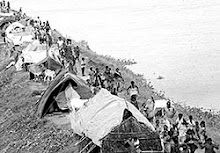
That is only one half the story. The other half about which no concern
is shown by anybody (Government and NGOs included) comprises of nearly
1.5 million people spread over 414 villages trapped between the two
embankments of the Kosi which is the route of the normal river flow in
a normal year. “We literally have our houses on our shoulders and
despite using weed or wood fired chulha for cooking, no cobwebs are
seen on our thatched roofs. We have to shift our houses much before
spiders start developing the webs”, says a resident of village
Nirmali, trapped between the two embankments of the Kosi in Supaul
district. Their problem is perennial just as the flow of the river.
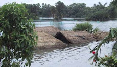
The team visited the Bhutahi Balan and the Kamla Balan basins and
finally landed up in the Bagmati where mammoth embankments are being
built or repaired. These are being raised and strengthened to provide
a greater degree of protection to the people living outside them. But
from Dheng to Runni Saidpur there is hardly any reach of the
embankment that has not faced the wrath of the river and the breaches
and yet the people and the Government believe that these structures
would protect them from floods.
That silt contained in the river waters is equally responsible for the
devastation that is caused by rising bed level of the rivers and
subsequent failure of the embankments can be seen in the villages of
Raksia and Ibrahimpur of Runnisaidpur block of Sitamarhi district. A
27 feet high mosque in Raksia is submerged in sand and only top 5 feet
is visible above the ground while a temple of Lord Shiva has to be dug
out every year from the sand to offer puja in the latter. Will the
engineers and the politicians ever recognize the secular behaviour of
our rivers?
The team was shocked by the joke that is played in the name of the
development in Kaala Pani area of Runnisaidpur. Nearly 75 squire
kilometers of land has been submerged because the embankments on the
Bagmati blocked the entry of the Manusmara into it and as if that were
not sufficient, the unprocessed effluents from a sugar mill were
dumped into the Manusmara to make the submergence black and stinking.
No agriculture is possible with such ‘waters’ and there has been no
crops in the area for the past ten years now. The farmers of Kaala
Pani remain engaged in agriculture, but in Punjab and Haryana.
.
Dinesh Kumar Mishra
Around a dozen Lok Sabha seats and 22 Bihar Vidhan Sabha seats fall in the Kosi belt. Congress-RJD-LJP is trying to make large-scale “destruction” as triggered by the Kosi as the main poll issue. It has been reported that Nitish Kumar, the chief minister did not visit those flood-affected districts during his month-long Yatra because the people in the Kosi belt or the victims of the Kosi disaster are hardly going to vote for the JDU-BJP regime.
The National Common Minimum Programme (CMP) of the Congress-RJD-LJP led Central Government made a solemn pledge to the people of the country in 2004 to undertake “Long-pending schemes in specific states that have national significance, like flood control and drainage in North Bihar.” Despite acknowledging the problem, it is shocking that neither the Central nor Bihar Government conducts any survey to assess the effect of flood control measures on the socio-economic conditions of society and chooses to ensure that status quo is manitained to safeguard the inhuman selfish interests of contractors in repair and construction.
Rashtriya Barh Ayog (National Flood Commission) was constituted in 1976 to evolve a coordinated, integrated and scientific approach to the flood control problems in the country and to draw out a national plan fixing priorities for implementation in the future. Its report was submitted in 1980 and accepted by Government but the implementation of its recommendations did not happen. Union Ministry of Water Resources set up an Expert Committee to review the Implementation of recommendations of Rashtriya Barh Ayog (RBA) in October. The Committee identified the bottlenecks faced by the state government in its implementation and suggested measures for implementation of RBA recommendations for effective Flood Management in the country.
On August 19, 2008, the chairman of this Expert Committee on the Implementation of recommendations of Rashtriya Barh Ayog (1980 report) said, “It is my impression that not much has been done to implement the suggestions made by the committee’s report.” And now a Commission of Inquiry has been constituted by the Government of Bihar under the chairmanship of Justice Rajesh Balia to enquire into the causes of breach in the Eastern Kosi Afflux Bund on 18th August 2008 so as to prevent occurrence of such disaster in future as if the same is not clear from the reports of the previous Commissions, Committees and Task Forces.
Gopal Krishna
Barh Mukti Abhiyan Press Release
27th March 2009
“If it had not breached at Kusaha, it would have anyway breached at
this point,” points a villager towards the probable location on the
eastern bank in village Rajabaas near Prakashpur in Sunsari district
of Nepal, located 14 km upstream of Kusaha where the Eastern Afflux
embankment of the Kosi had breached on the August 18, 2008.
The river has indeed come close to the embankment at the site and with
the spurs that protect the embankment in no good condition, a
potential danger lurks. The setting is seemingly perfect for another
breach! The state has just woken up, collecting stones for the
protection work in case the river decides to gnaw the embankment.
Should that happen, what course the river would adopt before it joins
that Ganga is not known just as it was not known the course last year
following the breach at Kusaha?
So, that’s what the Water Resources Department leaves it during this
year to be reaped (faced) by the Disaster (mis)Management Department
of the state. Since there is no dialogue between the two, the vicious
cycle gets perpetuated year after year.
That is the inference of a team of 15 professionals and social workers
that visited the area hit by last year’s devastating floods of the
Kosi during March 21-27, 2009. The team noted that the repair works at
Kusaha are far from complete although the engineers at site claim that
they will complete the work to their ‘entire satisfaction’ by April
20, 2009, eight months after the last year’s disaster, before fresh
water reaches the site following snow-melt in upper catchment. This
claim will have to be verified in days to come.
Everyone hopes that they are not caught on the wrong foot again! The
Kosi flood disaster of 2008 was spread over 5 districts, 35 blocks,
993 villages affecting 33.29 lakh people and spread over an area of
3.68 lakh hectares in India alone which resulted in loss of nearly 600
persons and destruction of 2.37 lakh houses. But for the colour of the
sand, a vast area of the Kosi basin now resembles Jaisalmer
(Rajasthan) and may need the help of the experts of Central Arid Zone
Research Institute CAZRI, Jodhpur for revival of agriculture in the
region.
That is only one half the story. The other half about which no concern
is shown by anybody (Government and NGOs included) comprises of nearly
1.5 million people spread over 414 villages trapped between the two
embankments of the Kosi which is the route of the normal river flow in
a normal year. “We literally have our houses on our shoulders and
despite using weed or wood fired chulha for cooking, no cobwebs are
seen on our thatched roofs. We have to shift our houses much before
spiders start developing the webs”, says a resident of village
Nirmali, trapped between the two embankments of the Kosi in Supaul
district. Their problem is perennial just as the flow of the river.
The team visited the Bhutahi Balan and the Kamla Balan basins and
finally landed up in the Bagmati where mammoth embankments are being
built or repaired. These are being raised and strengthened to provide
a greater degree of protection to the people living outside them. But
from Dheng to Runni Saidpur there is hardly any reach of the
embankment that has not faced the wrath of the river and the breaches
and yet the people and the Government believe that these structures
would protect them from floods.
That silt contained in the river waters is equally responsible for the
devastation that is caused by rising bed level of the rivers and
subsequent failure of the embankments can be seen in the villages of
Raksia and Ibrahimpur of Runnisaidpur block of Sitamarhi district. A
27 feet high mosque in Raksia is submerged in sand and only top 5 feet
is visible above the ground while a temple of Lord Shiva has to be dug
out every year from the sand to offer puja in the latter. Will the
engineers and the politicians ever recognize the secular behaviour of
our rivers?
The team was shocked by the joke that is played in the name of the
development in Kaala Pani area of Runnisaidpur. Nearly 75 squire
kilometers of land has been submerged because the embankments on the
Bagmati blocked the entry of the Manusmara into it and as if that were
not sufficient, the unprocessed effluents from a sugar mill were
dumped into the Manusmara to make the submergence black and stinking.
No agriculture is possible with such ‘waters’ and there has been no
crops in the area for the past ten years now. The farmers of Kaala
Pani remain engaged in agriculture, but in Punjab and Haryana.
.
Dinesh Kumar Mishra
Wednesday, 18 February 2009
Kosi High Dam Multipurpose Project DPR preparation underway
Government of India is in constant dialogue with the Government of Nepal. For early implementation of high dams on river Kosi, Kamla and Bagmati in Nepal.
For this purpose, a Joint Project Office -Saptakosi and Sunkosi Investigations (JPO-SKSKI) has already been set up in August, 2004 at Biratnagar (Nepal), for conducting detailed field investigations, in order to prepare Detailed Project Report(s) of Sapta Kosi High Dam Multipurpose Project and Sun Kosi Storage-cum-Diversion Scheme in Nepal, jointly.
In addition, JPO-SKSKI has also been entrusted the task of carrying out the Feasibility Level Study of Kamala Multipurpose (Dam) Project and the Preliminary Study of Bagmati Dam Project in Nepal.
This information was given by the Minister of State for Water Resources, Jai Prakash Narayan Yadav in response to a question by Moinul Hassan in the Rajya Sabha.
February 17, 2009
Ministry of Water Resources
Thursday, 8 January 2009
Threats to the security of Ganga basin
Isn't diversion of Ganga, and its tributaries through Interlinking of Rivers project or Kosi High Dam, the biggest threats to the security of Ganga basin?
Almost echoing the words of Dr Dinesh Kumar Mishra, B G Verghese submits that Kosi region "...is possibly being the most blighted part of the entire country The flood has wiped the slate clean. We have a wonderful opportunity to write a completely new script that could put North Bihar in the vanguard of India’s social and economic progress. But none has as yet shown the imagination to do so."
" Repairing the breach in the Kosi’s eastern embankment in Nepal will not guarantee the safety of the 50 year-old Bhimnager barrage" which It has been a long- standing Nepalese grievance that this barrage was built just within its boundary with Bihar and not further upstream, thereby providing Nepal greater flood protection, irrigation and energy benefits. That is history."
But the danger lies in his prescription for engineering solution that is quite contrary to the Ganga basin approach that Prime Minister's Office has announced. Verghese says, " If the Bhimnagar barrage has outlived its lifer, could/should it not be replaced by a new barrage optimally sited further north. Could that also possibly serve as the re-regulating dam for the proposed Kosi High Dam (Barakshetra)-cum-Kurule-Sun Kosi diversion for which a joint detailed project report long under preparation is now to be expedited? In combination, the High Dam and new barrage could help regulate the river and moderate floods, some of the flood being diverted at Kurule into the Sun Kosi and thence beneficially into the water-stressed Kamla basin within Nepal."
He also submits revealing his support for Interlinking of Rivers project saying, "An additional possibility would be diverting some of the Kosi storage eastwards into the Mechi river that marks Nepal’s border with West Bengal. This could in turn augment the flows of the Mahananda and Teesta to resolve an Indo-Bangla argument."
But again he partly and deceptively echoes Dr Mishra, "Further, should the Kosi be fully restored to its pre-August 2008 embanked channel via the Bhimnagar barrage, so as to maintain the existing irrigation system, or should the new eastern arm that has opened up along an old alignment be also kept alive?" but very soon retreats into the make believe worl of structural engineering.
Verghese does not realize the limitations of his suggestions "With some desiltation and training works, this could be converted into the proposed navigation channel to link Nepal to the sea, an aspect of the High Dam study. This second channel could also serve as a flood-reducer by diverting high monsoon flows into yet another channel."
Vergese feels that "The World Bank and ADB would surely assist any credible programme, including dam building, and carbon credits could defray some of the costs."
Despite global financial crisis it is amazing that trust in these institutions remains intact.
Tuesday, 6 January 2009
What are the biggest threats to Ganga basin?
Initiating a structured discussion on the Ganga river basin-covering parts of Nepal, India, Tibet and Bangladesh- wherein approximately one in twelve people in the world live, considered submission of 400/500 words are invited from a holistic perspective to comprehend and articulate the crisis that has emerged from the current fragmented and fractured approach of the governments, academia, civil society and corporations of commerce and religion.
Being a moderated discussion, participants are expected to stay focused around the lead questions:
What is Ganga River Basin approach? Does it apply to only 79% of Ganga basin, which is in India? Will it include 13 % of Ganga basin that is in Nepal, 4 % in Bangaldesh and 4 % in Tibet? What is its relationship with the river systems and with the composite Ganga-Brahmputra-Meghna basin and its consequences?
How does it affect the policies of Industry, Power, Agriculture, Urban Development, Health and Environment by the central government, the governments of eleven states (Bihar, Chhattisgarh, Haryana, Himachal Pradesh, Jharkhand, Madhya Pradesh, NCT of Delhi, Rajasthan, Uttranchal, Uttar Pradesh and West Bengal), the neighboring countries and industry bodies like CII/FICCI/ASSOCHEM/PHCCI?
What is the relevance of Ganga River basin approach when the river channel has been amputated from the flood plains besides the amputation of the river channel itself?
Will the Third Phase of Ganga Action Plan (GAP) or the proposed the Ganga River Basin Authority which is to consider its formation in a meeting likely to be held on January 15 and its proposed river basin approach affect the quality of surface water, ground water and the survival of natural flow of the rivers in the basin? (The GAP-I which was to be completed by March 1990 was extended till March, 2000 when it was declared complete but Phase I of the Plan is not yet fully complete and GAP-II which was to be completed in 2001 was extended till December 2008. This too remains incomplete)
What is the meaning of the official ceremonial and ornamental status being accorded to Ganga just prior to the upcoming parliamentary elections?
Which among the following are the biggest threats to Ganga basin?
a. National Interlinking of Rivers project of NDA & UPA,
b. UP’s Ganga Expressway project,
c. Uttarakhand’s Bhairon Ghati, Loharinag-Pala, Pala Maneri and Maneri Bhali hydro-projects
d. Some 191 heavily polluting industries in the Ganga basin states
e. West Bengal’s Farraka Barrage
f. Bihar’s Interlinking of Rivers project or Kosi High Dam
g. Pollution from “Religious” Activities
h. Corporate funding of political parties
i. Co-opted NGOs
What is required is not yet another Authority but genuine basin approach to overcome these threats.
Given the significance of the discussions, general submissions to the list will be held back (only most important submissions will get posted).
Friday, 2 January 2009
Kosi Breach and Beyond
Interaction on ‘The Kosi Breach and Beyond’
Living with the Kosi
At a meeting on - 17 December 2008 in Patna, experts from Nepal and India grapple with watery issues.
By Shiven Thapa
Thousands of years ago, hunter-gatherer societies discovered that hunting alone is insufficient for their long-term survival and they subsequently took to farming. In need of perennial sources of water for their crops, they moved to lands that were close to rivers. As much as the rivers became the lifeblood of these societies, the natural process of occasional flooding led human settlers to either ‘learn to live with the flow’ or ‘manage’ it.
Thus, began the epic struggle between these two divergent approaches, which ceaselessly continue to awe and shock humans till date – evident from the 18 August flooding of the plains of north Bihar and India, as the Kosi River breached its eastern embankment, and devastated lives and livelihoods, as it has done for more than one millennium. With this breach, the Kosi has carved out a new route altogether and there is a river now where there was earlier none. The Kosi has shifted 120 km eastwards, going back to a course it had abandoned more than 300 years ago and in so doing; it has rendered more than 300 km of embankments useless. On 27 August, the Prime Minister of India, Manmohan Singh declared the floods in Bihar a “national calamity”. The Kosi floods have left more than two million people homeless, and destroyed 250,000 homes, including 247,000 acres of farm land.
To take stock of this tragedy and encourage further debate on the issue, Barh Mukti Abhiyan and Himal Southasian organised a day-long conference in Patna on 17 December titled The Kosi Breach and Beyond. Water experts, engineers, activists, policymakers, researchers and journalists from India and Nepal participated in the meeting, and deliberated on the following issues of concern:
High dam vs. no dam
-There is a need to look at high dam proposals and the Kosi in the context of the broader India-Nepal water relationship.
-India is averse to Nepal receiving multilateral assistance on high dam projects.
-Where is the money and overall capacity for mammoth projects?
-If a high dam is built on the Kosi, massive displacement and submergence of areas will take place.
-Ethnic groups in Nepal are questioning the implications of a high dam on the proposed model of federal states.
-Large high-tech projects are the fantasies of ambitious rulers and do not rank on the cost-benefit scale.
-The 1950s was an era of engineers, the 1990s that of environmentalists, and in this decade, anthropologists also have a role to play – floods and dams cannot be confined to only engineering solutions.
-If a high dam is to be constructed upstream, three questions need to be answered – how much land will be submerged; is it earthquake-prone; and how much bio-diversity will be lost?
-Embankments are now being discredited in a coordinated way to build up a case for high dams on the Kosi.
-There is a contradiction between flood control and power generation – dams cannot be serving both purposes simultaneously.
-Multipurpose dams have limitations because of contradictory goals.
-The merits of the school of thought which says we should live with the floods, and advocates for a non-technological and non-interventionist solution.
Bureaucracy, policy and politics
-Bureaucratic red tape in India and Nepal – When the Kosi office in Biratnagar writes to the Ministry of Water Resources in Kathmandu, the complaint/query/suggestion is sent to the Ministry of Foreign Affairs. The Foreign Ministry then sends the note to the Ministry of External Affairs in New Delhi, which forwards it to the Bihar Government, which in turn dispatches it to the Kosi office located in Birpur.
-A parallel economy operates in the embankment areas due to the politician-contractor nexus. Until this is broken, innovative solutions to the annual Kosi crisis will be difficult to come by.
-There are major gaps between estimated and real areas irrigated. (see Dinesh Kumar Mishra’s table in Himal article.)
-National water policies of Nepal, Bihar and Uttar Pradesh appear to be similar.
-Government decisions are based on impulses – policymakers will never live to see the result of their decisions.
Solutions to the Kosi floods
-The best way out of the Kosi crisis is an integrated river basin approach.
-Social, environmental, economic costs must be measured – the Bhakra Nangal dam can be studied.
-Community centred, decentralised water management is needed – pick a tributary and be creative.
-Reductionist engineering interventions must be avoided.
-Lessons can be learnt from the Yellow River in China – they have built a dam that also generates 20,000 MW of electricity.
-Yearning for a permanent solution ignores the fact that engineering is simply a discipline of experiments.
Most issues raised during this interaction converged on the view that mainstream thinking on river management and engineering solutions have remained in a state of denial despite evidence to the contrary. The belief in embanking and damming remains as it was. The high dam proposals floating around in policy circles in India and Nepal claim to be a ‘permanent solution’, but overlook the dangers of seismicity. Moreover, water-related discussions in Southasia have often tended to focus on macro-level issues such as droughts, floods, rivers, dams, and irrigation, but without end-user involvement. There is also little evidence of intra-research community linkages, and no institutional mechanisms appear to be in place to share findings in a sustained manner. Studies on rivers in Southasia fail to take a comprehensive view of the river system – the river is often studied in isolation to the ecological system of which it forms an integral part. Clearly, the Kosi too cannot be understood in isolation.
WATCH OUT FOR EXTENSIVE REPORTAGE AND ANALYSIS IN HIMAL’S FEBRUARY 2009 ISSUE!
About the event:
Himal Southasian and Barh Mukti Abhiyan brought together 26 eminent water experts, engineers, activists, policymakers, researchers and journalists from India and Nepal for a day-long "Interaction on the 'Kosi Breach and Beyond'"
As the waters released by the 18 August breach of the eastern embankment above the Kosi Barrage at Kausaha in Nepal slowly recede, media coverage of the tragedy is fast dwindling both in Nepal and India. Given the impact of the Kosi inundation, which affects a large number people in one of Southasia’s poorest regions, and also due to the complicated geopolitical dimension of this cross-border river, it is important that a scientific, people-centered and humanitarian response be evolved.
One of the main focus of the event was the discussion on the impact of the recent breach, as also the viability of the different alternatives, including a) keeping the Kosi confined within the existing embankments; b) building a high dam; c) other possible engineering solutions; and d) going back to the historical experience of living with the flood in the plains, and adjusting livelihoods and infrastructure to the annual inundation.
Contact us at shiven@himalmag.com or at +977-1-5552141 for any queries regarding the event.
Programme:
Date: 17 December 2008
Venue: Hotel Ambassador, Patna, India
Welcome note: Dinesh Kumar Mishra
Introductory remarks: Kanak Mani Dixit
Session one:
Discussion on Kausaha Breach and status
Session two:
Status of proposed Kosi High Dam
Session three:
Consolidation of the proceedings for the day and open discussion
Participants list:
Ameet Dhakal
CK Lal
Dinesh Kumar Mishra
Dr Arun Dhoj Adhikary
Dr. V.N. Sharma
Devashish Chatterjee
Dunu Roy
Gopal Krishna
Hari Roka
Kalyan Rudra
Kanak Mani Dixit
Kavindra Pandey
Prashant Jha
Prof C.P. Sinha
Rajendra Dahal
Rajendra Singh
Sankar Ray
Tula Narayan Shah
Uday Shankar
Chandra Kishore Jha
Abhay Mohan Jha
Source: http://himalmag.com/The-Kosi-Breach-and-Beyond_dnw105.html
Subscribe to:
Posts (Atom)