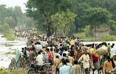
Refusing to learn anything from past mistakes the embankments are still being built or repaired in Kosi and Bagmati. Kosi flood disaster of 2008 was spread over 5 districts, 35 blocks, 993 villages affecting 33.29 lakh people and spread over an area of 3.68 lakh hectares in India alone which resulted in loss of nearly 600 persons and destruction of 2.37 lakh houses. And nearly 1.5 million people spread over 414 villages trapped between the two embankments of the Kosi which is the route of the normal river flow in a normal year. There is no reason to believe that similar crisis be witnessed this year too.
Around a dozen Lok Sabha seats and 22 Bihar Vidhan Sabha seats fall in the Kosi belt. Congress-RJD-LJP is trying to make large-scale “destruction” as triggered by the Kosi as the main poll issue. It has been reported that Nitish Kumar, the chief minister did not visit those flood-affected districts during his month-long Yatra because the people in the Kosi belt or the victims of the Kosi disaster are hardly going to vote for the JDU-BJP regime.
The National Common Minimum Programme (CMP) of the Congress-RJD-LJP led Central Government made a solemn pledge to the people of the country in 2004 to undertake “Long-pending schemes in specific states that have national significance, like flood control and drainage in North Bihar.” Despite acknowledging the problem, it is shocking that neither the Central nor Bihar Government conducts any survey to assess the effect of flood control measures on the socio-economic conditions of society and chooses to ensure that status quo is manitained to safeguard the inhuman selfish interests of contractors in repair and construction.
Rashtriya Barh Ayog (National Flood Commission) was constituted in 1976 to evolve a coordinated, integrated and scientific approach to the flood control problems in the country and to draw out a national plan fixing priorities for implementation in the future. Its report was submitted in 1980 and accepted by Government but the implementation of its recommendations did not happen. Union Ministry of Water Resources set up an Expert Committee to review the Implementation of recommendations of Rashtriya Barh Ayog (RBA) in October. The Committee identified the bottlenecks faced by the state government in its implementation and suggested measures for implementation of RBA recommendations for effective Flood Management in the country.
On August 19, 2008, the chairman of this Expert Committee on the Implementation of recommendations of Rashtriya Barh Ayog (1980 report) said, “It is my impression that not much has been done to implement the suggestions made by the committee’s report.” And now a Commission of Inquiry has been constituted by the Government of Bihar under the chairmanship of Justice Rajesh Balia to enquire into the causes of breach in the Eastern Kosi Afflux Bund on 18th August 2008 so as to prevent occurrence of such disaster in future as if the same is not clear from the reports of the previous Commissions, Committees and Task Forces.
Gopal Krishna
Barh Mukti Abhiyan Press Release
27th March 2009
“If it had not breached at Kusaha, it would have anyway breached at
this point,” points a villager towards the probable location on the
eastern bank in village Rajabaas near Prakashpur in Sunsari district
of Nepal, located 14 km upstream of Kusaha where the Eastern Afflux
embankment of the Kosi had breached on the August 18, 2008.
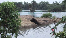
The river has indeed come close to the embankment at the site and with
the spurs that protect the embankment in no good condition, a
potential danger lurks. The setting is seemingly perfect for another
breach! The state has just woken up, collecting stones for the
protection work in case the river decides to gnaw the embankment.
Should that happen, what course the river would adopt before it joins
that Ganga is not known just as it was not known the course last year
following the breach at Kusaha?
So, that’s what the Water Resources Department leaves it during this
year to be reaped (faced) by the Disaster (mis)Management Department
of the state. Since there is no dialogue between the two, the vicious
cycle gets perpetuated year after year.
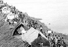
That is the inference of a team of 15 professionals and social workers
that visited the area hit by last year’s devastating floods of the
Kosi during March 21-27, 2009. The team noted that the repair works at
Kusaha are far from complete although the engineers at site claim that
they will complete the work to their ‘entire satisfaction’ by April
20, 2009, eight months after the last year’s disaster, before fresh
water reaches the site following snow-melt in upper catchment. This
claim will have to be verified in days to come.
Everyone hopes that they are not caught on the wrong foot again! The
Kosi flood disaster of 2008 was spread over 5 districts, 35 blocks,
993 villages affecting 33.29 lakh people and spread over an area of
3.68 lakh hectares in India alone which resulted in loss of nearly 600
persons and destruction of 2.37 lakh houses. But for the colour of the
sand, a vast area of the Kosi basin now resembles Jaisalmer
(Rajasthan) and may need the help of the experts of Central Arid Zone
Research Institute CAZRI, Jodhpur for revival of agriculture in the
region.
That is only one half the story. The other half about which no concern
is shown by anybody (Government and NGOs included) comprises of nearly
1.5 million people spread over 414 villages trapped between the two
embankments of the Kosi which is the route of the normal river flow in
a normal year. “We literally have our houses on our shoulders and
despite using weed or wood fired chulha for cooking, no cobwebs are
seen on our thatched roofs. We have to shift our houses much before
spiders start developing the webs”, says a resident of village
Nirmali, trapped between the two embankments of the Kosi in Supaul
district. Their problem is perennial just as the flow of the river.
The team visited the Bhutahi Balan and the Kamla Balan basins and
finally landed up in the Bagmati where mammoth embankments are being
built or repaired. These are being raised and strengthened to provide
a greater degree of protection to the people living outside them. But
from Dheng to Runni Saidpur there is hardly any reach of the
embankment that has not faced the wrath of the river and the breaches
and yet the people and the Government believe that these structures
would protect them from floods.
That silt contained in the river waters is equally responsible for the
devastation that is caused by rising bed level of the rivers and
subsequent failure of the embankments can be seen in the villages of
Raksia and Ibrahimpur of Runnisaidpur block of Sitamarhi district. A
27 feet high mosque in Raksia is submerged in sand and only top 5 feet
is visible above the ground while a temple of Lord Shiva has to be dug
out every year from the sand to offer puja in the latter. Will the
engineers and the politicians ever recognize the secular behaviour of
our rivers?
The team was shocked by the joke that is played in the name of the
development in Kaala Pani area of Runnisaidpur. Nearly 75 squire
kilometers of land has been submerged because the embankments on the
Bagmati blocked the entry of the Manusmara into it and as if that were
not sufficient, the unprocessed effluents from a sugar mill were
dumped into the Manusmara to make the submergence black and stinking.
No agriculture is possible with such ‘waters’ and there has been no
crops in the area for the past ten years now. The farmers of Kaala
Pani remain engaged in agriculture, but in Punjab and Haryana.
.
Dinesh Kumar Mishra
Subscribe to:
Post Comments (Atom)


No comments:
Post a Comment