Tuesday, 23 September 2008
The Worst Is Yet To Come
Why, after 60 years of band-aid remedies for the Kosi, is there no lasting
solution yet, asks GOPAL KRISHNA
ON AUGUST 19, 2008, the chairman of the Expert Committee on the Implementation
of recommendations of Rashtriya Barh Ayog, R Rangachari said, “It is my
impression that not much has been done to implement the suggestions made by the
committee’s report.” Rangachari was on the Prime Minister’s Task Force on Flood
Control in 2004.
The National Common Minimum Programme (CMP) of the Government of India made a
solemn pledge to the people of the country in 2004 to undertake “Long-pending
schemes in specific states that have national significance, like flood control
and drainage in North Bihar.” Despite acknowledging the problem, it is shocking
that neither the Central nor Bihar Government conducts any survey to assess the
effect of flood control measures on the socio-economic conditions of society.
On August 20, 2008, after the breach in the embankment at Kusaha in the Kosi
region, Nepalese Prime Minister Pushpa Kamal Dahal `Prachanda’, took stock of
the post-calamity situation in the Kosi region and said “Kosi agreement was a
historic blunder. The people are suffering due to this”. The agreement had led
to the construction of embankments and proposals for a high dam.
Following an aerial survey of the flood affected areas of Bihar, the Indian
Prime Minister on August 28, 2008, termed the flood crisis as “a national
calamity”. More than four years have passed since the Indian Prime Minister made
the promise in the CMP. Now, in August 2008 he declared, “A high-level team
would be set up to coordinate matters with the Government of Nepal.” He also
promised protective structures and technical assistance to state government to
prevent further deterioration in the embankments. Such dangling of carrots and
providing band-aid remedies are horribly insincere and it has been going on for
over 60 years.
Bihar’s floods in August 2008 caused the eighth breach in the embankments.
According to the Bihar Government’s own reports, last year 48 lakh people in 22
districts were in need of assistance due to floods. Clearly, it is not the
extent, but the unpredictable intensity of the crisis that makes it a
catastrophe. The primary function of floodwater is to drain out excess water. It
has not been allowed to perform its functions due to engineering interventions.
Hundreds of reports prepared by Commissions of all ilks are gathering dust. At
most, they become election campaign tools. The Commission should recommend
fixing charges of criminal neglect against the members of the Kosi High-Level
Committee, who waited for the calamity despite having information that could
have led to timely evacuation of the people.
The drainage problem has failed to alter the policy regime of the country that
favours structural solutions regardless of the natural drainage it may impede.
Proposals like a high dam on the Kosi are as good as jumping from the frying pan
into the fire, if the experience with embankments is anything to go by. Even
when one chooses to ignore the changing morphology of the river, the estimated
lifespan of a dam and embankment being 25 and 37 years respectively, underlines
the transitory nature of the technocentric interventions. The Union Ministry of
Water Resources misled the Rajya Sabha on March 11, 2008 claiming, “Government
has taken various steps in the direction of water management to stop the flood
in north Bihar coming from the rivers of Nepal.” There has been no significant
shift in the way the Kosi issue was perceived in the 1950s and in 2008.
The issue of the Kosi High Dam, first raised in 1948, has been sold to the
victims as one of the ‘permanent’ solutions to recurring floods. Ironically,
embankments as temporary solutions have become reasonably permanent whereas the
‘permanent’ solution has remained elusive. What is ‘permanent’ and how permanent
is ‘permanence’? It must be acknowledged now that there is a condemnable
insincerity in proposing multi-purpose high dams for flood control, because the
dams are proposed to tap the hydropower potential. Is it not clear that when the
multipurpose — flood control, irrigation and power — dam is talked about, the
real motive of the proposal in question is ignored? Clearly, political parties
hold a stake in such power projects that make them little concernend with the
masses struggling to remain afloat. A few days ago, Nepalese Prime Minister,
Prachanda, conveyed his affirmation for the hydel power project in a meeting
with Bihar Chief Minister Nitish Kumar at a lunch hosted by JD(U) leader Sharad
Yadav.
THERE IS a compelling logic behind seeking immediate review of the Indo- Nepal
Kosi Treaty that created the rationale for embankments and dams. Continuing with
it would amount to flogging a dead horse. The congestion in North Bihar and
Nepal is a problem of permanent water-logging that has remained overlooked for
several decades. Floods, earthquakes, hurricanes or tsunamis cannot be
controlled. But the catastrophe they cause can be predicted, anticipated and
prevented. Drainage of the river must remain sacrosanct, besides timely
evacuation of human and animal population and the establishment of robust public
health systems.
Given its distinct geo-morphological features and complicated hydrological
characters, the Kosi is one of the Himalayan rivers that has yet to be
understood in its entirety. It is high time that policy makers gave up their
outdated ‘conquest over nature’ paradigm. We have to learn to live with the
floods, only this time, in far more readiness.
(Gopal Krishna is a member of the fact finding misson on the Kosi in Bihar and
Nepal)
From Tehelka Magazine, Vol 5, Issue 38, Dated Sept 27, 2008
Of Deluge, Candles and Matchboxes
by Dinesh Kumar Mishra
The foundation stone of the Kosi Project was laid on January 14, 1955 amidst fanfare, jubilation and victory. Dr. Shrikrishna Sinha, thgen Chief Minister of Bihar, laid the foundation stone near Bhutaha village close to Nirmali, in Saharsa (now Supaul) district with the chanting of mantras by Pt. Mahabir Jha of Jhitki village and shouting of slogans like 'Aadhi Roti Khayengein, Kosi Bandh Banaayengein.' (We will eat only half a chapati but we will surely build the Kosi embankments). A majority of people lost the other half of the bread too on the 18th August 2008 when the Kosi embankment breached on that day.
Col. Townsend of the US Army while deliberating in a seminar organized by the American Society of Civil Engineers to discuss the Mississippi floods of 1927 had said that even the best designed and carefully constructed embankments remain at the mercy of burrowing animals like rats, foxes, muskrats who can create a hole in the finest levee that has been devised, which if not closed within a few moments will ensure its destruction. The Mississippi River of the United States broke loose in 1927 inundating an area of 51,200 sq. kilometer and damaging property to an estimated extent of two hundred million to a billion dollars. The breaches drove nearly three quarters of a million people from their homes and six hundred thousand of them were dependant on Red Cross. The wealth and power of the United States enabled much to be done for the sufferers, still they suffered. He further added a 'careless supervisor and dark nights' to the list destroyers of embankments. His observations remain valid till date as the Kosi comes out of its shackles in Kusaha in Nepal some 13 kilometers upstream of the Kosi Barrage. All the eight breaches that have occurred so far can be brought under these categories.
Col. Townsend gave benefit of doubt to the planners and engineers when he prefixed 'best designed and carefully constructed' adjectives to the embankments. The Kosi has breached its embankment eighth time and it is for the first time that the 'disaster' has generated so much of interest. These embankments are spaced at an average distance of 9 to 10 kilometers below the barrage with a maximum width of 16 kilometres between Kisunipatti and Bhaptiahi and minimum width of nearly 3 kilometres at the barrage itself. The spacing of the embankments is only 8 kilometres at the tail end, between Baluaha Ghat and Ghonghepur. In Nepal portion the spacing between them is restricted to between 3 to 6 kilometers. Common sense suggests that the spacing between the embankments should increase as the river advances further as more and more streams join the river from western side. This simple common sense was kicked around when these embankments were constructed in late 1950s. There were 304 villages with a population of 192,000 (1951 census) going to be trapped between the embankments and each one of them was trying to be located outside the embankments. Later the embankments were extended and 380 villages of Bihar and 34 villages of Nepal came within them. Their current population is nearly 1.2 million. The village locations were fixed and it was the embankment on either side of the river that could be moved. So did it happen. Now the embankment alignment is a caricature of what it was designed, if there was any design.
Chinese Deputy Prime Minister Teng Tse Hui discussing the floods in the Hwang Ho had once said in 1955 that according to historical records, there have been inundations and breaches on 1500 or more occasions on the lower reaches of the river and there were 26 important changes of course, nine of them major…..The terrible floods of 1933 caused more than 50 breaches of the dykes and brought disaster to more than 11,000sq. km. Over 3,640,000 people were affected and over 18,000 killed. Property worth some 230 million Yuans was lost. In 1938, Chiang Kai Shek Government opened the dykes on the south bank of the river at Huayuan Kou near Cheng Chow in Honan province. This led to a major change in the course of the river affecting 54,000 sq. km. with a population of 12,500,000 and 890,000 people died….In a hundred years, from 1855 till 1955, the dykes had breached on 200 occasions. According to an on the spot survey in the river bed in lower reaches was found to be rising by one to ten centimeters every year in the middle of this century. In some cases the existing river bank was found even ten meters higher than the surrounding country level. Such rapid silting cannot be dealt with simply by piling up and reinforcing dykes. In a sense, higher and stronger the dykes, the quicker is the silt deposited because it has no way of getting out. The Kosi embankments were constructed citing the wonderful performance of these two rivers.
Had Col. Townsend been living today, he must have amended his statement saying that the embankments could be ill-conceived, ill-designed and poorly constructed too. Capt. G.F. Hall, former Chief Engineer of Bihar was of the opinion that the embankments can only postpone the day of retribution and will be a store of disaster for the future generation. A status paper prepared by Government of Bihar in 2003 suggests that those who subscribe to such views are the people of colonial mindset.
The 'nationalist' embankment builders had a last laugh when they succeeded in bringing Dr. Rajendra Prasad, then President of India' to Bihar between 17th to 22nd October 1954 and made him request the people to participate in the 'yagna' of nation building by constructing the Kosi embankments. His views in the Patna Flood Conference (1937) were diagonally opposite to what he was made to say in 1954. One can imagine the stress the President might have undergone during that trip of his home state of Bihar.
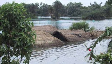
Embankments prevent a river from overflowing its banks during floods but they also prevent the entry of floodwater. This leads to a major problem as the embanked river is no longer able to fulfill its primary function – draining out excess water. With the tributaries prevented from discharging into the river and accumulated rainwater finding no way out, the surrounding areas quickly become flooded. The situation is aggravated by seepage from under the embankments. The areas outside the levees remain waterlogged for months after the rainy season because this water has no way of flowing out to the sea. Theoretically, sluice gates located at these junctions should solve the problem but, in practice, such gates quickly become useless; as the bed level of the main river rises above the surrounding land, operating the gates lets water out instead of allowing outside water in. When the sluice gates have failed, the only option left is to also embank the tributary. This results, then, in water being locked up between the embankments. Moreover, no embankment has yet been built or can be built in future that will not breach. When a breach occurs, there is a deluge. This is what happened at Kusaha this year on the 18th August 2008.
Proponents of embankments have tried to rationalize the jacketing of rivers thus: Forcing the same quantity of water through a narrow area, as happens in case of an embanked river, increase the water velocity thereby increasing its eroding capacity. The increased velocity of water dredges the river bottom and transports the sediment out preventing the rise of riverbed levels, increasing the carrying capacity of the river and reducing the extent of flooding. These were the arguments put forward by engineers in independent India when they resorted to massive embanking of rivers in the Ganga and the Brahmaputra basin. Unfortunately, there has been little evidence to date that this theory is actually being substantiated anywhere on Indian rivers. The technical debate, however, continues at that level.
At the field level in the flooded areas of Bihar, there is a continuing debate on polythene sheets, rice, vegetables, salt, candle and match-boxes etc. How strategic is this deflection of debate that the people discuss keep discussing about sattu (ground gram), chura (flattened rice) candles and matchboxes. This is what precisely the politicians want and if they are not brought to the real issues of dealing with the sediments, floodwaters, accountability and an informed debate; the event would simply pass of as the earlier ones.
The foundation stone of the Kosi Project was laid on January 14, 1955 amidst fanfare, jubilation and victory. Dr. Shrikrishna Sinha, thgen Chief Minister of Bihar, laid the foundation stone near Bhutaha village close to Nirmali, in Saharsa (now Supaul) district with the chanting of mantras by Pt. Mahabir Jha of Jhitki village and shouting of slogans like 'Aadhi Roti Khayengein, Kosi Bandh Banaayengein.' (We will eat only half a chapati but we will surely build the Kosi embankments). A majority of people lost the other half of the bread too on the 18th August 2008 when the Kosi embankment breached on that day.
Col. Townsend of the US Army while deliberating in a seminar organized by the American Society of Civil Engineers to discuss the Mississippi floods of 1927 had said that even the best designed and carefully constructed embankments remain at the mercy of burrowing animals like rats, foxes, muskrats who can create a hole in the finest levee that has been devised, which if not closed within a few moments will ensure its destruction. The Mississippi River of the United States broke loose in 1927 inundating an area of 51,200 sq. kilometer and damaging property to an estimated extent of two hundred million to a billion dollars. The breaches drove nearly three quarters of a million people from their homes and six hundred thousand of them were dependant on Red Cross. The wealth and power of the United States enabled much to be done for the sufferers, still they suffered. He further added a 'careless supervisor and dark nights' to the list destroyers of embankments. His observations remain valid till date as the Kosi comes out of its shackles in Kusaha in Nepal some 13 kilometers upstream of the Kosi Barrage. All the eight breaches that have occurred so far can be brought under these categories.
Col. Townsend gave benefit of doubt to the planners and engineers when he prefixed 'best designed and carefully constructed' adjectives to the embankments. The Kosi has breached its embankment eighth time and it is for the first time that the 'disaster' has generated so much of interest. These embankments are spaced at an average distance of 9 to 10 kilometers below the barrage with a maximum width of 16 kilometres between Kisunipatti and Bhaptiahi and minimum width of nearly 3 kilometres at the barrage itself. The spacing of the embankments is only 8 kilometres at the tail end, between Baluaha Ghat and Ghonghepur. In Nepal portion the spacing between them is restricted to between 3 to 6 kilometers. Common sense suggests that the spacing between the embankments should increase as the river advances further as more and more streams join the river from western side. This simple common sense was kicked around when these embankments were constructed in late 1950s. There were 304 villages with a population of 192,000 (1951 census) going to be trapped between the embankments and each one of them was trying to be located outside the embankments. Later the embankments were extended and 380 villages of Bihar and 34 villages of Nepal came within them. Their current population is nearly 1.2 million. The village locations were fixed and it was the embankment on either side of the river that could be moved. So did it happen. Now the embankment alignment is a caricature of what it was designed, if there was any design.
Chinese Deputy Prime Minister Teng Tse Hui discussing the floods in the Hwang Ho had once said in 1955 that according to historical records, there have been inundations and breaches on 1500 or more occasions on the lower reaches of the river and there were 26 important changes of course, nine of them major…..The terrible floods of 1933 caused more than 50 breaches of the dykes and brought disaster to more than 11,000sq. km. Over 3,640,000 people were affected and over 18,000 killed. Property worth some 230 million Yuans was lost. In 1938, Chiang Kai Shek Government opened the dykes on the south bank of the river at Huayuan Kou near Cheng Chow in Honan province. This led to a major change in the course of the river affecting 54,000 sq. km. with a population of 12,500,000 and 890,000 people died….In a hundred years, from 1855 till 1955, the dykes had breached on 200 occasions. According to an on the spot survey in the river bed in lower reaches was found to be rising by one to ten centimeters every year in the middle of this century. In some cases the existing river bank was found even ten meters higher than the surrounding country level. Such rapid silting cannot be dealt with simply by piling up and reinforcing dykes. In a sense, higher and stronger the dykes, the quicker is the silt deposited because it has no way of getting out. The Kosi embankments were constructed citing the wonderful performance of these two rivers.
Had Col. Townsend been living today, he must have amended his statement saying that the embankments could be ill-conceived, ill-designed and poorly constructed too. Capt. G.F. Hall, former Chief Engineer of Bihar was of the opinion that the embankments can only postpone the day of retribution and will be a store of disaster for the future generation. A status paper prepared by Government of Bihar in 2003 suggests that those who subscribe to such views are the people of colonial mindset.
The 'nationalist' embankment builders had a last laugh when they succeeded in bringing Dr. Rajendra Prasad, then President of India' to Bihar between 17th to 22nd October 1954 and made him request the people to participate in the 'yagna' of nation building by constructing the Kosi embankments. His views in the Patna Flood Conference (1937) were diagonally opposite to what he was made to say in 1954. One can imagine the stress the President might have undergone during that trip of his home state of Bihar.
Embankments prevent a river from overflowing its banks during floods but they also prevent the entry of floodwater. This leads to a major problem as the embanked river is no longer able to fulfill its primary function – draining out excess water. With the tributaries prevented from discharging into the river and accumulated rainwater finding no way out, the surrounding areas quickly become flooded. The situation is aggravated by seepage from under the embankments. The areas outside the levees remain waterlogged for months after the rainy season because this water has no way of flowing out to the sea. Theoretically, sluice gates located at these junctions should solve the problem but, in practice, such gates quickly become useless; as the bed level of the main river rises above the surrounding land, operating the gates lets water out instead of allowing outside water in. When the sluice gates have failed, the only option left is to also embank the tributary. This results, then, in water being locked up between the embankments. Moreover, no embankment has yet been built or can be built in future that will not breach. When a breach occurs, there is a deluge. This is what happened at Kusaha this year on the 18th August 2008.
Proponents of embankments have tried to rationalize the jacketing of rivers thus: Forcing the same quantity of water through a narrow area, as happens in case of an embanked river, increase the water velocity thereby increasing its eroding capacity. The increased velocity of water dredges the river bottom and transports the sediment out preventing the rise of riverbed levels, increasing the carrying capacity of the river and reducing the extent of flooding. These were the arguments put forward by engineers in independent India when they resorted to massive embanking of rivers in the Ganga and the Brahmaputra basin. Unfortunately, there has been little evidence to date that this theory is actually being substantiated anywhere on Indian rivers. The technical debate, however, continues at that level.
At the field level in the flooded areas of Bihar, there is a continuing debate on polythene sheets, rice, vegetables, salt, candle and match-boxes etc. How strategic is this deflection of debate that the people discuss keep discussing about sattu (ground gram), chura (flattened rice) candles and matchboxes. This is what precisely the politicians want and if they are not brought to the real issues of dealing with the sediments, floodwaters, accountability and an informed debate; the event would simply pass of as the earlier ones.
Monday, 22 September 2008
Kosi’s chilling history: No lessons ever learnt
Kosi’s chilling history: No lessons ever learnt
Inder Malhotra
WAY BACK in 1953, I had the privilege of accompanying Jawaharlal Nehru to Bihar. In those days, within the country, the Prime Minister travelled by an IAF Dakota. Even so, he decided to increase the number of journalists in his party from two to six, the additional four being foreigners, in equal strength from the two power blocs. The cause of the visit was intensely grim and he obviously wanted the outside world to witness it. Kosi, then called Bihar’s "river of sorrow", now renamed "river of misery", had wrought havoc — though it would have paled in comparison with this year’s catastrophic floods.
For four days, by plane, rail and car, Nehru visited as much of the ravaged areas as possible, offering solace to the sufferers and issuing terse instructions to officials in charge of rescue, relief and resettlement of those whose worldly possessions had been washed away. On his way back to Delhi, he told us that basically the tragedy was a natural disaster about which nothing could have been done. But, he hastened to add, that man’s contribution to nature’s fury, in terms of lack of imagination, competence and even compassion, together with lackadaisical action, was "more than considerable." He also said that since Kosi flowed from Nepal into India, the two countries would take steps jointly to control the floods.
Judging by what the luckless seven districts of the state have gone through since August 18, it seems that little has changed in 55 years. Or else there would not have been the plethora of complaints about the "tardiness" and "inadequacy" of the governmental and administrative response to a tragedy of huge magnitude. This despite the fact that between 1953 and the start of 2008 there have been several devastating floods caused by the same wayward river.
According to several reliable reports, neither Patna nor New Delhi were fully aware of the flood’s frightening dimensions. At the Centre, precious days were wasted in the mistaken belief that the recently-established Disaster Management Board would be able to deal with the problem. Only when the error became manifest was the Army called in and naval boats and divers mobilised. Even then, the relief effort was far from satisfactory. There was a constant lament about the shortage of boats. The other side of the same coin was that in several cases, families precariously perched on the roofs of their flooded huts, simply refused evacuation.
Most people may have forgotten that during the Emergency there was a terrible flooding of a coalmine at Chasnala, also in Bihar, in which a large number of miners had to fight for their survival in the deluge. The country did not have a pump powerful enough to draw out water from that depth. Eventually, the Soviet Union flew out one, and many lives were saved. Surely, India does not lack motorboats except that they are spread out at myriad places. Could they not have been requisitioned and flown to the submerged region? The story goes that at the height of the tragedy, some in New Delhi were planning to buy motor-engines to fit on locally available boats.
This depressing state of affairs was aggravated by the apparently deathless blame game. That between the Union and the state government — the former accusing the ministry in Patna of "ignoring the warnings" and the latter accusing the former of failing to provide "timely help" — can be treated as an inescapable part of the Indian system. Far more destructive is the blame game between this country and Nepal.
Ramaswamy R. Iyer, a former Union water resources secretary and an assiduous scholar of water-related problems, has summed up the situation succinctly, if also rather mildly. "The India-Nepal relationship," he says, "has been badly mismanaged on both sides. Ham-handedness and insensitivity on India’s part, and excessive touchiness and readiness to misunderstand on Nepal’s part, have combined to create a convoluted and volatile relationship which resists repair." This should explain why the 1954 Agreement on Kosi and the 1960 one on Gandak continue to be a source of resentment in Nepal even though both agreements were later amended to meet Nepali concerns. To make matters worse, the crucial Mahakali Agreement remains a dead letter to this day. No wonder, Mr Ramaswamy wants to "wipe the slate clean and start afresh." It is to be hoped that South Block and Nepal’s new Republican government share this approach. From this point of view, the visit to Delhi of Nepali Prime Minister Prachanda is timely.
Interestingly, despite the exchange of acerbic and heated rhetoric between Nepal and India, there is conspicuous agreement between the water experts in both countries. For instance, Nepal’s Deepak Gyawati fully agrees with Mr Ramaswamy and several other Indians that the Kosi Barrage, badly breached by gushing waters, should never have been built, and that embankments built to control the flow of Kosi have done more "harm than good". On these highly technical matters I can offer no opinion except that the government must examine them expeditiously and having taken decisions ensure that these are implemented more earnestly than has been the case so far.
Some have pertinently drawn comparisons between the admirable efficiency with which all agencies concerned in Tamil Nadu coped with the tsunami disaster of 2004 and the wailing and whining that has greeted the manner in which Kosi’s challenge has been met in Bihar. A retired civil servant commented that in Tamil Nadu, during the tsunami crisis, collectors of all affected districts waded through waste-deep water every day. He doubts if anything comparable happened in Bihar that was once among the best administered states but is now among the worst.
Remarkably, it was a Bihar civil servant who said that a precise code exists since the British days according to which it is the bounden duty of district authorities to strengthen the embankments before every monsoon but nobody pays it any heed. However, why blame collectors of Madhepura and other Bihar districts when the much-pampered Municipal Corporation of Delhi miserably fails to clean up the drains before monsoon and lets the nation’s capital to be waterlogged year after year?
The Asian Age, Sept 18, 2008
Wednesday, 17 September 2008
Kosi High Dam will only bring great disasters
Drainage Crisis of North Bihar & Nepal Remains Unattended
New Delhi/17/09/2008: All talk about seeking review of Kosi agreement that created the rationale for embankments and dams on the Kosi river seems like empty rhetoric. The Nepalese prime minister who has reportedly said that he favoured the idea of setting up a high dam on the river Kosi (though it doesn't appear on the Joint Press Statement), at a meeting with Bihar chief minister at meeting hosted by President of JD (U) in Delhi on September 16, 2008. Leaders from Nepal and India have agreed to set up a new mechanism headed by the water resources secretaries of both countries to discuss issues related to flood control, strengthening the embankments and water management.
This is a welcome step provided it is credible, open and independent review of the experience of the past treaty over the last five decades. It is only through such a review in a participatory, democratic way that contours of future steps emerge. Any talk of big dams in absence of this seems like vested interests pushing a high cost project for reasons other than merits of the project, which is the situation today.
The Kosi agreement that was signed in 1954 was amended in 1966 to address Nepal's concerns. According to the treaty, the repair and maintenance of the embankment was India's responsibility. "It is clear that the embankment breached on Aug 18, due to the criminal neglect of those who were responsible at Govt of India and Bihar for the proper upkeep of the embankment. Govt of India has yet to set up an enquiry as to who is responsible for the worst ever flood disaster that Kosi basin in Nepal is facing today. Jumping to push high dam on Kosi, is an invitation to even greater disaster and the new Nepali government seems to be walking into that trap".
"The proposed Kosi High dam is in a highly geologically unstable and earth quake prone area - a recipe for disaster in the waiting. Besides the inherent dangers, there is also a growing evidence of dam-induced seismicity that is being completely overlooked. The proposed dam (even if we consider the highest proposed height) would silt up sooner than 40 years, according to government's own reports. The silt from it cannot be released, as that silt would only end up again in the Kosi embankment and in the downstream Farakka, which would be an invitation to even greater disaster of Ganga bypassing the Farakka, already waiting to happen.,
"The rulers will have people believe that completing the projects (although a dam will take about 20 years for completion) especially a dam) tame the Kosi and solve the flood problem. It is being suggested to the Nepal Prime Minister that the Saptakosi high dam project besides Sunkosi diversion scheme and the Kamla dam project at a combined estimated cost of Rs. 38,000 crore would address the crisis in Bihar and Nepal. These claims need to be summarily rejected."
It is noteworthy that the proposed dam is supposed to be for multiple purposes (irrigation, power-generation, flood-control, etc), and there is an in built conflict in-built into such projects. Flood-control would require the intended space in the reservoir to be kept vacant for accommodating flood-waters, whereas irrigation or power-generation would require the reservoir to be as full as possible; and as the latter are gainful activities in an economic sense, they are apt to prevail over flood-control. If the space meant for accommodating floods is not available when the flood comes, the gates will have to be opened in the interest of the safety of the dam, and the downstream area might experience a greater flood than it would have done if the dam had never been built. This has happened in the past. In fact experience of Surat in 2006, of west Medinipur in W Bengal and Lakhimpur in Assam in June this year show that in fact flood disasters can be caused by wrong operation of large dams, the those quilty never get punished.
The Kosi High Dam proposal measures against the following facts:
1. The National Flood Commission, 1980, had noted: "The flood problem being more acute in the basins of rivers originating from the Himalayas, the reservoirs for flood moderation have to be sited in the Himalayan region, where there are complex problems to be dealt with in putting up large dams due to geological, seismic and topographical constraints. Because of narrow valleys, capacities of reservoirs on Himalayan rivers are not very large. Also, the rivers carry very large silt charge. The factors limit the economic life of the reservoirs, which, in turn, affects the economic feasibility of the project."
2. The idea of 269-metre Kosi dam was first mooted in 1937 and has been projected to have a lifespan of no more than 37 years, owing to about 90 million cubic meters of silt being carried by the river each year. Thanks to faster-than-expected silting of the reservoir of the proposed dam, neither will it produce the promised power nor provide intended irrigation benefits. The learned public representative must know that the existing East Bank Kosi canal is heavily silted and delivers just 7 per cent of its irrigation potential.
3. While the proposal has conveniently ignored the issue of displacement and rehabilitation of over 75,000 Nepalese, the populist nature of the appeal discounts the fact that it will not be before next 20 years that the proposed dam will actually get built at a whopping cost of over Rs 50,000 crore. The flood plains of Kosi have immediate problems at hand, created and caused by the embankments that need to be addressed. North Bihar needs sustainable solutions and not technocratic interventions, which cannot guarantee protection from floods
"In the context of the proposed dam, it must be remembered that it is the same area where earthquake-measuring 8.3 on the Richter scale hit Nepal/Bihar in 1934. The real crisis of North Bihar is not floods but drainage, which the UPA's Common Minimum Programme acknowledged. But did you hear anyone talk about responding to the drainage crisis, which has rightly been diagnosed as the real problem,
What we need to do urgently is to institutionalise participatory governance in the Kosi basin, so that people in whose name all this is being pushed have a role. What is claimed to be solutions today are certain to be problem tomorrow, as is clear from the experience of Kosi embankment. Kosi and its people will not allow more of such faulty prescriptions. Kosi belongs to the ecosystem and all of society. The river must be allowed to perform its role in maintaining a natural evolutionary balance and continuing with its land building work.
For Details Contact: Dinesh Kumar Mishra: Mb-09431303360, Sudhirendar Sharma: Mb-9868384744, Himanshu Thakkar: Mb-9968242798, Gopal Krishna: Mb-9818089660
Monday, 15 September 2008
कोसी को बांधा नहीं जा सकता
पिछले कई सालों से न सिर्फ केन्द्र सरकार ने बल्कि बिहार सरकार ने भी बाढ़ कार्यवाही योजना का गलत निर्धारण किया है। सन 1954 से जब नेपाल इस मामले में एक पक्ष बना है तबसे लगातार पूरी जिम्मेदारी नेपाल पर थोपना काफी आसान हो गया है। तथ्यान्वेषण दल को यह देखकर अचम्भा हुआ कि न तो केन्द्र सरकार और न ही बिहार सरकार ने यह आकलन करने के लिए कोई सर्वेक्षण किया है कि बाढ़ नियंत्रण उपायों का समाज के समाजिक आर्थिक परिस्थिति पर क्या प्रभाव पड़ा है। यही स्थिति नेपाल में भी है।
तथ्यान्वेषण दल का यह मानना है कि मौजूदा समस्या का मूल कारण तटबंध ही नहीं है। दल इस स्थिति के हल के लिए निश्चित नीति निर्णय चाहता है। हालांकि जिसे गैरकानूनी माना जाता है, लेकिन पानी में फंसे लोग अपने आस-पास जमा पानी को निकालने के लिए तटबंध को तोड़ने का सहारा लेते रहते हैं। इसके पक्ष में सामान्य सोच यह है कि तटबंधों को तोड़ने से कोई अनचाही परिस्थिति नहीं पैदा होती है।
भारत में तटबंधों को तोड़ने के प्रमाण भी हैं। दामोदर नदी में 1854 में बने 32 किमी लम्बे तटबंध को 1869 में ढहा दिया गया। ब्रिटिश सरकार को बहुत जल्दी यह महसूस हो गया कि इससे बाढ़ नियंत्रण नहीं होता, तटबंधों से उपजाऊ जमीने डूब में जा रही थीं, जिसके लिए उन्हें मुआवजा देने को बाध्य होना पड़ता था। तथ्यान्वेषण दल के लेखक श्री सुधीरेन्द्र शर्मा के अनुसार, ''तटबंध टुटने के कारण मुआवजा देने की सबसे पहली घटना 1896 की है जब पश्चिम बंगाल के बर्दवान जिले में किसानों को 60,000 रुपये मुआवजा दिया गया।''
हॉलैंड में राइन और मियूस नदी को बांधने में असफल रहने पर वहां के जलविज्ञानियों ने सुरक्षा का एक खास तरीका अपनाया है जिसे 'नदी के उन्मुक्त प्रवाह की जगह' कहा जाता है। इस नई आवधारणा न सिर्फ जानकारी युक्त चर्चा की जरूरत है बल्कि यह व्यापक राजनैतिक समर्थन पर आधारित है। ऐसे उपायों पर उत्तर बिहार के निवासियों से चर्चा करके निष्कर्ष पर पहुंचने की जरूरत है, लेकिन इसके लिए केन्द्र सरकार और बिहार सरकार के बीच आपसी सहमति की जरूरत है।
जब तक दोषी अधिकारियों एवं संस्थाओं को जवाबदेह नहीं बनाया जाएगा तब तक न सिर्फ वे पिछली गलतियां दोहराई जाएंगी बल्कि नई अवधारणाओं और रणनीतियों को लागू करना भी मुश्किल होगा। यह बात जल संसाधन से जुड़ी संस्थाओं के मूल, क्रियाकलाप, और कानूनों से साफ होती है। वे सभी बड़ी परियोजनाओं के नियोजन, डिजाइन और क्रियान्वयन के लिए ही बनी हैं। यह बात भी साफ है कि वे भागीदारी युक्त या पारदर्शी संस्थाओं के प्रति इच्छुक भी नहीं हैं। ये संस्थाएं पूरी नदी घाटी की आवश्यकताओं, संसाधनों और प्राथमिकताओं को शामिल करने में असफल रही हैं। इस तरह ''मौजूदा संस्थाओं को पूरी तरह नये सिरे से खंगालने (परिभाषित) की जरूरत है'', ऐसा कहना है कोसी के तथ्यान्वेषण रिपोर्ट के सह-लेखक गोपाल कृष्ण का।
ऐसे मामलों में किसी न्यायिक या प्रशासनिक जांच से आपराधिक जिम्मेदारी नहीं तय होती है, क्योंकि ऐसे आयोगों और समितियों के निष्कर्ष तो निश्चित ही होते हैं। यह तो किसी परिणाम पर न पहुंचने की नियमित प्रक्रिया है। हालांकि, न्यायमूर्ति राजेश बालिया आयोग के विचारार्थ विषय में कोसी उच्च स्तरीय समिति के बारे में स्पष्ट किया गया है, लेकिन उसकी विशेषताओं पर ध्यान देने की जरूरत है। लेकिन ऐसे आयोगों की सबसे बड़ी सीमा यह होती है कि ये समस्या के लिए जिम्मेदार मौजूदा संस्थाओं से न तो सवाल करती हैं और न तो कर सकती हैं। आयोगों द्वारा तैयार ऐसी सैकड़ों रिपोर्टों में धूल पड़ रही हैं और उन्हें दीमक चाट रहे हैं। इनमें से ज्यादातर का उपयोग चुनावों में प्रचार के लिए होता है। इस तरह, सबकी परिणति एक जैसी होती है।
आइए इस आपदा पर भारतीय प्रधानमंत्री, बिहार के प्रधानमंत्री और बिहार के मुख्यमंत्री के बयान पर एक नजर डालते हैं। कोसी क्षेत्र के कुशहा में तटबंध में कटाव आने के बाद बिहार के मुख्यमंत्री ने 19 अगस्त 2008 को भारत के विदेश मंत्री से निवेदन किया कि वे कोसी समझौते के अनुसार नेपाल में कटाव के मरम्मत के लिए नेपाल सरकार को कानून व्यवस्था सुनिश्चित करने के लिए सम्पर्क करें।
नेपाल के सुंसारी जिले के लौकाही पुलिस थाना में 16 अगस्त 2008 उन असामाजिक तत्वों के खिलाफ एक प्राथमिकी दर्ज कराई गई है जिनके द्वारा ऐसी परिस्थिति उत्पन्न की गई कि सभी इंजिनियरों को वहां से भाग जाना पड़ा।
20 अगस्त 2008 को नेपाल के प्रधानमंत्री ने स्थिति का जायजा लेते हुए कहा कि, ''कोसी समझौता एक भयंकर ऐतिहासिक भूल थी'' और ''इसे लोग पीड़ित हैं''। समझौते की वजह से तटबंधों का निर्माण हुआ है और बड़े बाध का प्रस्ताव है। भारत के प्रधानमंत्री ने 28 अगस्त 2008 को बाढ़ग्रस्त इलाकों का हवाई सर्वेक्षण करने के बाद इस समस्या को ''राष्ट्रीय आपदा'' घोषित किया और राहत और पुनर्वास के लिए तत्काल 1000 करोड़ रुपये जारी करने की भी घोषणा की।
यह ध्यान देने योग्य है कि भारत सरकार ने 2004 में घोषित अपने राष्ट्रीय न्यूनतम सहमति कार्यक्रम के तहत उत्तरी बिहार के बाढ़ नियंत्रण, ड्रेनेज आदि योजनाओं को पूरा करने का संकल्प लिया था (जिसके लिए नेपाल सरकार की सहमति भी जरूरी है)। उस वादे को किए हुए चार साल हो गए लेकिन अब फिर अगस्त 2008 में उन्होंने कहा कि, ''नेपाल सरकार से समन्वय के लिए वे एक उच्च स्तरीय दल गठित करेंगे''। उन्होंने यह भी वादा किया कि तटबंध के मरम्मत, रखरखाव व सुरक्षा के लिए वे बिहार सरकार को आवश्यक तकनीकी सहायता भी उपलब्ध करएंगे। इस तरह की आश्वासन वाली बातें तो पिछले 60 सालों से की जा रहीं है। इससे पहले भारत सरकार ने नेपाल के जल संसाधन मंत्रालय के अंतर्गत जल आधारित आपदा निवारण विभाग के निवेदन पर 7 जुलाई 2008 को नदियों के तटबंध के मरम्मत व विकास के लिए अनुदान दिया था।
इन सबसे साफ है कि जमीनी स्तर पर जो भी बदलाव आए, ज्यादातर बाते वैसे ही रहती हैं। तटबंध के मरम्मत का कार्य जारी है और तात्कालिक हल के तौर पर उसके मार्च 2009 तक पूरा हो जाने की उम्मीद है। ऐसे समय में उत्तारी बिहार और नेपाल में कोसी के बाढ़ क्षेत्र का दौरा करके लौटे तथ्यान्वेषण दल की मांग है कि इस पूरी आपदा पर और खासकर उत्तरी बिहार में कोसी घाटी के ड्रेनेज (जलनिकासी) पर एक श्वेत पत्र जारी किया जाय। ताकि मौजूदा नीतियों के कारण बंद हुई ड्रेनेज समस्या को हल किया जा सके। इससे समस्या और बाढ़ प्रवण क्षत्र में बढ़ोतरी करने वाली तथाकथित विपरीत हल की परिस्थतियों का पता लगना चाहिए।
इस रिपोर्ट का कहना है कि बांध, तटबंध और उनकी मरम्मत जैसे बाढ़ नियंत्रण के उपायों से सिर्फ तात्कालिक राहत मिल सकती है। ऐसी परिस्थिति में नदी के बहाव क्षेत्र में बदलाव के कारकों का सूक्ष्म स्तर पर दीर्घकालीक और सावधानीपूर्वक अध्ययन की जरूरत है। यहां यह स्पष्ट करने की जरूरत है कि तटबंध के कटाव को बंद कर दने से ही समस्या का स्थायी हल नहीं हो जाएगा। परिवर्तनकारी जलविज्ञान को नजरअंदाज करने पर बांध और तटबंध की उम्र 25 साल होती है और बदलावों को ध्यान दते हुए तकनीकी सुधार करते हुए 37 साल होती है।
कोसी तटबंध में अब तक का यह आठवां कटाव है, जिसमें नेपाल के चार पंचायत, उत्तरी बिहार के 4 जिले सहरसा, सुपौल, मधेपुरा और अररिया इस बाढ़ से बुरी तरह प्रभावित हुए हैं। इनके अलावा 12 अन्य जिले पुर्णिया, खगड़िया, मुजफ्फरपुर, पश्चिमी चंपारण, सारण, शेखपुरा, वैशाली, बेगुसराय, पटना, और नालंदा भी इस बाढ़ से प्रभावित हुए हैं। एक अनुमान के अनुसार करीब 35 लाख लोग इस बाढ़ से प्रभावित हुए हैं। बिहार सरकार के रिपोर्टों के अनुसार पिछले साल 22 जिलों में 48 लाख लोगों को बाढ़ के कारण सहायता की जरूरत थी। इससे साफ है कि घटना के पैमाने का अनुमान न कर पाने से इतनी बड़ी आपदा आई। बाढ़ के पानी का सबसे पहला कार्य यह होता है कि अतिरिक्त पानी की निकासी करे। लेकिन इंजिनियरिंग हस्तक्षेप के करण ऐसा नहीं हो पाया।
अब तक न ऐसा कोई तटबंध बना है और न भविष्य में बनेगा जिसमें कटाव न आए। कोसी नदी के तटबंध में कटाव और पिछले नेपाली और भारत सरकार द्वारा बड़े बांध का प्रस्ताव के तर्क में इस बात पर ध्यान नहीं दिया गया कि कोसी को बांधा नहीं जा सकता।
अपने विशिष्ट भौगोलिक परिस्थितियों और जटिल जलविज्ञान के विशेषताओं के कारण कोसी एक ऐसी नदी है जिसके बारे में अभी व्यापक रूप से समझा जाना बाकी है। यह सही समय है कि नीति निर्माता ''प्रकृति पर नियंत्रण'' करने के अपनी पुरानी अवधारणा का त्याग करें और यह माने कि हमें बाढ़ के साथ जीना सीखना होगा।
विस्तृत जानकारी के लिए सम्पर्क करें।
सुधीरेन्द्र शर्मा : 9868384744, ईमेल : sudhirendar@vsnl.net
गोपाल कृष्ण : 9818089660, ईमेल : krishnagreen@gmail.com
Friday, 12 September 2008
Kosi Deluge: The Worst is Yet to Come
Press Release
Kosi Deluge: The Worst is Yet to Come
New Delhi/ 12/9/2008: Not only has Delhi got its flood action plan consistently wrong over the years, so has Patna. Consequently, it becomes convenient to transfer the entire blame on Kathmandu that was party to a mistake when it was first conceived in 1954. The Fact Finding Mission was aghast to observe that neither central nor Bihar government `conducts any survey to assess the effect of flood control measures on socio-economic condition of the society'. The same holds true for Nepal as well.
The Fact Finding Mission Report "Kosi Deluge: The Worst is Still to Come", asserts that embankments are the root cause of the present crises. It seeks firm policy decisions to remedy the situation. Though considered unlawful, trapped communities have time and again engaged in creating artificial breaches for draining their accumulated water from their surroundings. The general perception favours removal of embankments provided the act of demolishing does not create undesired conditions.
"There is a precedence of embankment demolition in India. The embankments created along a length of 32 kilometers on river Damodar in 1854 were demolished in the year 1869. The British had soon realized that far from controlling floods, the embankments were submerging fertile lands for which the colonial rulers were forced to provide compensation. The first-ever compensation of Rs 60,000 on account of submergence due to embankment failure was given to a farmer in 1896 in then Bardwan district," says Dr Sudhirendar Sharma, author, the Fact Finding Report on Kosi.
After their failure to tame rivers Rhine and Meuse, the Dutch hydrocracy has now adopted spatial flood protection measures called `room for the river'. The new approach not only warrants informed public debate but is based on broad political support. It is measures like these that need to be discussed and negotiated with communities in north Bihar, but not before the political stables in Patna (and in Delhi) get cleansed of their misconceptions!
"Unless the erring officials and institutions are held accountable, not only will the folly of the past get repeated but fresh approaches and strategies would be hard to implement. It is clear from the origin, functions and constitution of the institutions dealing with water resources. They are all structured for planning, design and implementation of large projects. It is also clear that they do not even intend to be participation oriented or open bodies. These institutions have failed to encompass the needs, resources and priorities of whole river basin. Therefore, a complete overhaul of the existing institutions is a dire necessity,' argues Gopal Krishna, co-author of the Fact Finding Report on Kosi.
Any judicial or executive probe that does not fix criminal liability is suspect because the fate such commissions and committees are a foregone conclusion. It is a routine exercise of no consequence. However, since the terms of reference of Justice Rajesh Balia Commission are clearly focused on Kosi High-Level Committee, a multilateral body, it merits some attention. But the biggest limitation of any such Commission is that it does not and cannot question the institutional status quo that is guilty of perpetuating the crisis. Hundreds of such reports prepared by Commissions of all ilk gather dust and are moth eaten. At most they become campaign tools during elections. Thus, one does all the running with all of one's might just to stay where one has always been.
A look at the statements of the Indian Prime Minister, the Nepalese Prime Minister and the Bihar Chief Minister demonstrates how they remain dedicated to the technocentric approaches that caused the calamity in the first place.
After the breach in the embankment at Kusaha in the Kosi region, Bihar Chief Minister requested India's External Affairs Minister on 19 August, 2008 to approach Nepal
Government to ensure law and order as per Kosi Agreement in order to repair the breach that took place in Nepal. On 16 August, 2008 an FIR was lodged in Laukahi Police Station in Sunsari district of Nepal against anti-social elements who created such as situation that all the engineers had to run away from their pots.
On 20 August, 2008, Nepal Minister took stock of the post-calamity situation in the Kosi region and said "Koshi agreement was a historic blunder" and "People are suffering due to this agreement". The agreement led to the construction of embankments and proposals for a high dam.
Following an aerial survey of the flood affected areas of Bihar by the Indian Prime Minister on August 28, 2008, termed the flood crisis as "a national calamity" and announced immediate release of Rupees 1000 crores to the Government of Bihar for rescue and relief.
It is noteworthy that National Common Minimum Programme of the Government of India announced in 2004 made a solemn pledge to the people of the country to undertake "Long-pending schemes in specific states that have national significance, like …flood control and drainage in North Bihar (that requires cooperation with Nepal as well)." More than four years have passed since the Indian Prime Minister made the promise and now in August 2008 he has declared, "A high-level team would be set up to coordinate matters with the Government of Nepal." He also promised "necessary material and technical assistance to the State Government to prevent further deterioration in the embankments and protective structures." Such dangling of carrots and providing Band Aid remedies are manifestly insincere and it has been going on for over 60 years.
Earlier, Indian government has provided grant assistance to Nepal for the construction of river embankments and emergent works in Nepal in response to the request made by the Department of Water Induced Disaster Prevention, Ministry of Water Resources, Government of Nepal on 7 July, 2008.
All this clearly demonstrates how although the more things change on the ground, the more they remain the same. While the repairs works are underway and will most likely be completed by March 2009 as an immediate protection measure, the Fact Finding Mission on Kosi that visited the flood affected parts of North Bihar and Nepal demands a white paper on the current deluge and drainage in the Kosi basin in particular and North Bihar & Nepal in general in order to address the drainage congestion crisis that has resulted from current policies. It must diagnose the problem and the adverse consequences of the so-called solutions that have caused huge increase in the flood prone area.
The report argues that while flood control measures like dams, embankments and their repairs can provide temporary respite. It is a phenomenon that needs long term careful micro level study of the factors causing shift in the course of the river. There has to be an acknowledgement that even if one fills the breach in the dam/embankment the problem does not get solved forever. Even when one chooses to ignore changing morphology, the estimated lifespan of a dam and embankment is 25 years and 37 years respectively underlines the transitory nature of technocentric interventions.
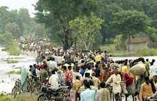
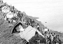
Following the eighth breach in th embankments, besides 4 panchayats in Nepal, four North Bihar districts- Saharsa, Supaul, Madhepura and Araria- got worst affected by floods. In addition to these twelve districts -- Purnia, Katihar, Khagaria, Muzaffarpur, West Champaran, Saran, Sheikhpura, Vaishali, Begusarai, Bhagalpur, Patna and Nalanda are affected by the floods as well. An estimated 35 lakh people have suffered due to the flood crisis. As per Bihar government own reports, last year 48 lakh people in 22 districts were in need of assistance due to flood. Clearly, it is not the extent but the unpredictable intensity of the crisis that makes it a catastrophe. The primary function of floodwater is to drain out excess water. It has not been allowed to perform its functions due to engineering interventions. The same fate awaits Bagmati and Mahananda region.
No embankment has yet been built or can be built in future that will not breach. The collapse of the Kosi river embankment and the rationale for proposed high dams was created by the previous Nepalese and Indian governments that did not realize that Kosi cannot be tamed.
Given its distinct geo-morphological features and complicated hydrological characters, the Kosi is one of the Himalayan rivers that has yet to be understood in its entirety. It is high time policy makers gave up their outdated "conquest over nature" paradigm and acknowledge `we shall have to learn to live with floods'.
For Details:
Sudhirendar Sharma:9868384744, E-mail: sudhirendar@vsnl.net
Gopal Krishna: 9818089660, E-mail: krishnagreen@gmail.com
Kosi Deluge: The Worst is Yet to Come
New Delhi/ 12/9/2008: Not only has Delhi got its flood action plan consistently wrong over the years, so has Patna. Consequently, it becomes convenient to transfer the entire blame on Kathmandu that was party to a mistake when it was first conceived in 1954. The Fact Finding Mission was aghast to observe that neither central nor Bihar government `conducts any survey to assess the effect of flood control measures on socio-economic condition of the society'. The same holds true for Nepal as well.
The Fact Finding Mission Report "Kosi Deluge: The Worst is Still to Come", asserts that embankments are the root cause of the present crises. It seeks firm policy decisions to remedy the situation. Though considered unlawful, trapped communities have time and again engaged in creating artificial breaches for draining their accumulated water from their surroundings. The general perception favours removal of embankments provided the act of demolishing does not create undesired conditions.
"There is a precedence of embankment demolition in India. The embankments created along a length of 32 kilometers on river Damodar in 1854 were demolished in the year 1869. The British had soon realized that far from controlling floods, the embankments were submerging fertile lands for which the colonial rulers were forced to provide compensation. The first-ever compensation of Rs 60,000 on account of submergence due to embankment failure was given to a farmer in 1896 in then Bardwan district," says Dr Sudhirendar Sharma, author, the Fact Finding Report on Kosi.
After their failure to tame rivers Rhine and Meuse, the Dutch hydrocracy has now adopted spatial flood protection measures called `room for the river'. The new approach not only warrants informed public debate but is based on broad political support. It is measures like these that need to be discussed and negotiated with communities in north Bihar, but not before the political stables in Patna (and in Delhi) get cleansed of their misconceptions!
"Unless the erring officials and institutions are held accountable, not only will the folly of the past get repeated but fresh approaches and strategies would be hard to implement. It is clear from the origin, functions and constitution of the institutions dealing with water resources. They are all structured for planning, design and implementation of large projects. It is also clear that they do not even intend to be participation oriented or open bodies. These institutions have failed to encompass the needs, resources and priorities of whole river basin. Therefore, a complete overhaul of the existing institutions is a dire necessity,' argues Gopal Krishna, co-author of the Fact Finding Report on Kosi.
Any judicial or executive probe that does not fix criminal liability is suspect because the fate such commissions and committees are a foregone conclusion. It is a routine exercise of no consequence. However, since the terms of reference of Justice Rajesh Balia Commission are clearly focused on Kosi High-Level Committee, a multilateral body, it merits some attention. But the biggest limitation of any such Commission is that it does not and cannot question the institutional status quo that is guilty of perpetuating the crisis. Hundreds of such reports prepared by Commissions of all ilk gather dust and are moth eaten. At most they become campaign tools during elections. Thus, one does all the running with all of one's might just to stay where one has always been.
A look at the statements of the Indian Prime Minister, the Nepalese Prime Minister and the Bihar Chief Minister demonstrates how they remain dedicated to the technocentric approaches that caused the calamity in the first place.
After the breach in the embankment at Kusaha in the Kosi region, Bihar Chief Minister requested India's External Affairs Minister on 19 August, 2008 to approach Nepal
Government to ensure law and order as per Kosi Agreement in order to repair the breach that took place in Nepal. On 16 August, 2008 an FIR was lodged in Laukahi Police Station in Sunsari district of Nepal against anti-social elements who created such as situation that all the engineers had to run away from their pots.
On 20 August, 2008, Nepal Minister took stock of the post-calamity situation in the Kosi region and said "Koshi agreement was a historic blunder" and "People are suffering due to this agreement". The agreement led to the construction of embankments and proposals for a high dam.
Following an aerial survey of the flood affected areas of Bihar by the Indian Prime Minister on August 28, 2008, termed the flood crisis as "a national calamity" and announced immediate release of Rupees 1000 crores to the Government of Bihar for rescue and relief.
It is noteworthy that National Common Minimum Programme of the Government of India announced in 2004 made a solemn pledge to the people of the country to undertake "Long-pending schemes in specific states that have national significance, like …flood control and drainage in North Bihar (that requires cooperation with Nepal as well)." More than four years have passed since the Indian Prime Minister made the promise and now in August 2008 he has declared, "A high-level team would be set up to coordinate matters with the Government of Nepal." He also promised "necessary material and technical assistance to the State Government to prevent further deterioration in the embankments and protective structures." Such dangling of carrots and providing Band Aid remedies are manifestly insincere and it has been going on for over 60 years.
Earlier, Indian government has provided grant assistance to Nepal for the construction of river embankments and emergent works in Nepal in response to the request made by the Department of Water Induced Disaster Prevention, Ministry of Water Resources, Government of Nepal on 7 July, 2008.
All this clearly demonstrates how although the more things change on the ground, the more they remain the same. While the repairs works are underway and will most likely be completed by March 2009 as an immediate protection measure, the Fact Finding Mission on Kosi that visited the flood affected parts of North Bihar and Nepal demands a white paper on the current deluge and drainage in the Kosi basin in particular and North Bihar & Nepal in general in order to address the drainage congestion crisis that has resulted from current policies. It must diagnose the problem and the adverse consequences of the so-called solutions that have caused huge increase in the flood prone area.
The report argues that while flood control measures like dams, embankments and their repairs can provide temporary respite. It is a phenomenon that needs long term careful micro level study of the factors causing shift in the course of the river. There has to be an acknowledgement that even if one fills the breach in the dam/embankment the problem does not get solved forever. Even when one chooses to ignore changing morphology, the estimated lifespan of a dam and embankment is 25 years and 37 years respectively underlines the transitory nature of technocentric interventions.
Following the eighth breach in th embankments, besides 4 panchayats in Nepal, four North Bihar districts- Saharsa, Supaul, Madhepura and Araria- got worst affected by floods. In addition to these twelve districts -- Purnia, Katihar, Khagaria, Muzaffarpur, West Champaran, Saran, Sheikhpura, Vaishali, Begusarai, Bhagalpur, Patna and Nalanda are affected by the floods as well. An estimated 35 lakh people have suffered due to the flood crisis. As per Bihar government own reports, last year 48 lakh people in 22 districts were in need of assistance due to flood. Clearly, it is not the extent but the unpredictable intensity of the crisis that makes it a catastrophe. The primary function of floodwater is to drain out excess water. It has not been allowed to perform its functions due to engineering interventions. The same fate awaits Bagmati and Mahananda region.
No embankment has yet been built or can be built in future that will not breach. The collapse of the Kosi river embankment and the rationale for proposed high dams was created by the previous Nepalese and Indian governments that did not realize that Kosi cannot be tamed.
Given its distinct geo-morphological features and complicated hydrological characters, the Kosi is one of the Himalayan rivers that has yet to be understood in its entirety. It is high time policy makers gave up their outdated "conquest over nature" paradigm and acknowledge `we shall have to learn to live with floods'.
For Details:
Sudhirendar Sharma:9868384744, E-mail: sudhirendar@vsnl.net
Gopal Krishna: 9818089660, E-mail: krishnagreen@gmail.com
Thursday, 11 September 2008
'Bihar is destined to die. Nobody counts us'
'Bihar is destined to die. Nobody counts us'
http://specials.rediff.com/news/2008/sep/02sli1.htm
"Who listens to us? Nobody. Biharis keep dying due to floods, but nation doesn't take notice of them. I know so many families in north Bihar who have lost their homes 14 times due to floods after Independence. Then, so what? Does anybody care for them? Do you know last year 960 people died due to floods in North Bihar? Nobody reads news from Bihar. That is Dinesh Kumar Mishra.
Environmentalist and engineer from IIT,62-year-old Mishra adds poignantly, "Bihar is destined to die. Nobody counts us."
Mishra is also the convenor of Barh Mukti Abhiyan, which tries to organise communities in Bihar's flood-prone areas. It already has, he says, 700 rural groups of "flood historians".
"The coming 30 days will be chaotic in north Bihar because till October you cannot repair the embankment fully. Second, even now, nobody knows how many people are trapped in flooded areas waiting for rescue team. It is very important that rescue teams reach out to all the people in flooded areas soon," says Mishra.
"Until, rescue teams penetrate villages, nobody will be able to guess correctly the real situation.People have lost monsoon crop because rivers have submerged the farms. Two, they will lose subsequent crops too because Kosi river has spread sand all over area. It will take almost a decade to get rid of this deposit of sand fully. In other words, floods mean that more and more poor people will have to migrate because there will be no employment on farms," says Mishra.
"It is the goodness of the poor that they don't commit suicides," Mishra adds..
He says there is an urgent need of food, medicines, drinking water and fodder for animals at various relief camps in Bihar. The displaced, he says, will have to be fed for two months or so.
While giving a grim picture of stark reality of lakhs of marooned families in north Bihar, he says, "When flood sweeps any village, the dignity of family members takes a beating.Har admi har admi se bepurdah ho jata hai. (People who are marooned lose shame.) Everything is done in public. You imagine the plight of family taking refuge at higher places. They do everything in open. Even when a women delivers baby she can't ask for privacy."
Mishra's mission is to understand the floods across India, particularly of rivers of Bihar, mainly Kosi. He says, "Nadion se mohabbat ho gayi hai." (I am besotted with rivers.)
The engineer uses his knowledge to link people with government and policy makers.
Talking about the current situation, he says, "The government claims that 56 people have died, but in Nepal at Kushaha (where embankment got breached ) eyewitnesses say 100 people died there only."
Mishra, who has a deep knowledge of floods, says, "Its difficult to figure out the actual number of deaths due to floods. During floods, many die due to snake bites, house collapse and boat capsizes. Unless the body is found and identified, government doesn't declare a person dead due to floods. For so many years, we have seen that at gates of Farrakka barrage over Ganga, dead bodies are found sometimes after floods in north Bihar. Kosi meets Ganga and there is no obstacle to flow of Ganga up to Farakka barrage in West Bengal. One never knows exactly how many people have died in floods in Bihar."
He says floods are harsh realities. He is fighting for the policy of prevention of flood and relief measures. Since 1984, Mishra has been advocating decentralized ways of coping with floods. He travels across India to educate people, living on banks of rivers, about traditional flood management systems. He reminds people that they have cultural ownership over rivers and any preventive or relief measures of floods should be people-centric.Mishra, so far unsuccessfully, is trying to create a new paradigm of flood control.
Working for the rights of victims of floods, he has written a moving story of river Kosi Dui Patan Ke Beech.
Mishra says in 1984 he was asked to prepare a report by a friend on the floods at Hempur village in Saharsha. Since then he had been witnessing year after year unbelievable human trauma due to floods in North Bihar and elsewhere.
That year, too, the embankment on the Kosi had breached and more than 450,000 people were stranded. Neither government nor political leaders had any idea about the floods.
He says without Nepal giving site to build a dam, India can not move further. The problem is that Kosi river has too big a catchment area and that will face water logging. Nepal will try to save its side and its people in case of heavy rains and will keep control of gates in it's hands.Even now, around 10 lakh people live between river and the embankment area.
The slit of Kosi river is such that a big dam may not be a final solution, he says.
Even today, around 9 lakh hectares of land of North Bihar remains flooded every year.
More than 80 lakh people get affected even in normal years when heavy rains raises water levels.
He told rediff.com, 'Biharis are uncared for. Biharis who sit in Parliament are also not taken seriously.When floods take away everything, more and more Biharis end up on the footpaths of Mumbai or Delhi or Gujarat."
When they are pushed away from there,they will come back to face another flood.
Mishra has studied the micro and macro aspects of floods of Bihar.
To get a thorough knowledge, he parked himself in the National Library of Calcutta for a year. Mishra has read debates over taming of the Kosi since British times.
He says, " Kosi's waters are not giving us as much problems as the slit that it carries. Because of slit, bed level increases and along with it there is need to raise the heights of embankments."
But, that hasn't happened. This year even the repairs work could not happen. He says normally around February technical advisory committee meets.The estimates are made, tenders are announced and budget gets passed. But somehow these didn't happen this time, he alleges.
For the last few years, has tried to understand why the Centre and state governments back out in finding permanent solutions of flooding rivers of Bihar. His extra-ordinary scholarly studies are available in his first book Barh Se Grast (Those Afflicted by Flood)
Mishra has written books on Mahananda and Kamla rivers, too.
"There is no two opinion that the floods of this year is due to negligence. The repair work of embankments is responsibility of the state government.Sometimes they are able to repair it and sometimes not, he says.
He says in 1963, 1968,1971,1980,1984,1987 and 1991 similar floods have come due to similar breach in embankments of rivers in Bihar.
Mishra says, "Bihar is India's most flood-prone state. According to government figures, in 1952, around 25 lakh hector area in Bihar was flood affected but now, 68.8 lakh hector of land in Bihar is flood-prone. In north Bihar, almost 76 per cent of land is flood-prone."
When asked why TV footage and photographs show such stark poverty of the displaced, he said, "North Bihar is one of the most-densely populated areas. There is too much pressure on land. More people depend on the land then it can sustain."
"What is needed is a drainage commission. We are unable to drain out flood waters. That is our biggest tragedy," Mishra says.
Despite all the destruction over the years, he says, no solution has been found yet.
"Every time some decisive moment comes suddenly nothing moves further," says Mishra.
He argues, 'Probably, there are three factors behind inaction on part of the Central and state governments in taming Kosi. If government decides to build a dam over Kosi, it can be built on the Nepal side only. Nepal will gain through power generation but, it will have only one buyer for it. India will have only one seller. This option of limited market is not encouraging for both sides to spend money on dam. Also, in the operation of dam, power generation project and maintenance of the site there will be too much dependence on Nepal. The huge project will be in entirely on a different land. Third, from point of view ofstrategic defence, it doesn't look like a good idea for government."
Those who wish to help the victims can contact Dinesh Kumar Mishra at the following address:
The Convenor, Barh Mukti Abhiyan
Road No: 6, B Rajiv Nagar
Patna 800024
Bihar.
Mobile:09431303360
E-mail: dkmishra108@gmail.com
NOte: Dr Dinesh Kumar Mishra was a key member of the Fact Finding Mission on Kosi. Mission's report is due for release on 12 September in Delhi.
Missing the river for the dam
The simplistic notion that a high dam in upper reaches can bring down the impact of floods in Kosi seems reflective of failed Indian hydrocracy, an expression gaining currency in regional water discourses. Raising contentious high dam issue at this stage, when the political atmosphere in Nepal is charged in favour of annulling all previous treaties including the 1954 Kosi treaty, will amount to diplomatic arrogance.
Nepal has long argued that a high dam doesn’t favour her, and that the projected benefits have been grossly exaggerated. These claims have been further accentuated by the raw deal reportedly received in the previous water-sharing arrangements, including the 1959 Gandak treaty. The present deluge upstream of the Bhimnagar barrage on Kosi has only amplified the accumulated aspersions.
The dilapidated state of the barrage could not convince this writer and other members of an independent fact-finding mission in early March that it could carry its designed discharge of 950,000 cusecs. The silt choked east and the west bank canals emanating from the barrage, their combined irrigation capacities reduced by two-third on account of defunct silt ejectors, could only add pressure on the main structure and the embankments upstream.
Sharing preliminary findings with the press, the fact finding mission had warned: “...not only are floods in Bihar manmade but that the worse has yet to come, should the political economy of flood control continue to promote ‘embankment’ as the only solution to the scourge of floods.” That the worse would come so soon couldn’t be predicted, but it undoubtedly had the making of a catastrophe.
Delhi has got its flood action plan consistently wrong over the years, and so has Patna. Yet, both never stop either blaming the rains or Kathmandu for it. Like floods, it is an annual ritual for politicians in Bihar to reiterate that Nepal has released water and that a high dam is the only solution to control floods. Little do unsuspecting masses realise that if there is no dam, how could water be stored upstream? But the myth persists!
Shockingly, however, flood control measures over the years have turned north Bihar into a watery grave for thousands. Jacketing the silt-laden rivers has helped flood prone area increase three fold in the state since Independence, from a low of 25 lakh to a high of 68 lakh hectare today. It amounts to no less than 73% of the entire land mass that remains prone under normal floods.
It is tragic that a catastrophic flood only sends alarming signals, emergency aerial surveys and fresh relief packages being the temporary outcomes. That over two million people are permanently trapped between the flood control embankments and an estimated eight million are faced with acute water-logging outside of the embankments are hard facts that continue to get ignored, year after year.
What instead gets attention is jacketing of the rivers, over 3,465 km long embankments have been built in Bihar since 1952. More are in the offing; a Rs 792-crore package to tame the Bagmati has been approved and another proposal to embank the tributaries of Mahananda at an estimated cost of Rs 850 crore has been planned. The business of embankment building reflects politician-bureaucrat-contractor nexus at its best.
But for those who stand to gain from it, embankment efficacy has always been suspect. Engineer Captain F C Hirst, in 1908, had commented, “in recent times, on the left bank of the Kosi, in the Purnea district, private enterprise has copied the work of the makers of the Bir Band, giving temporary relief, which, as will be seen later, is probably a menace to future welfare”. This century old observation has proved prophetic ever since.
Embankments may work on those rivers that are stable and carry moderate silt load. Kosi, in contrast, is a meandering river with maximum available energy producing currents. Having drifted 160 km in the past 250 years, the natural tendency of the meandering Kosi disproves the traditional ‘steady-state’ equilibrium approach of the engineers. Once embanked, its incredible silt load only adds to its defiant nature.
The embankments have proven counterproductive in the case of Kosi: arresting the natural dispersion of sediment on the floodplains, thereby increasing deposition, raising the level of riverbed and later breaking of embankments, causing floods and water-logging. Thanks to embankments, Kosi riverbed has risen by 12-15 feet on account of silt deposition that otherwise would have been spread on the floodplains.
It is erroneous to assume that north Bihar is geographically positioned to remain flooded. Conversely, it’s the state’s arrogance and misplaced faith in engineering that has stopped these rivers from performing their natural task of land building. Without the nurturing role of these rivers, Bihar would never have become the apex centre of knowledge. The collapse of this knowledge culture within the state is an outcome of embankment.
Can high dam over Kosi reverse Bihar’s misfortune? Like the embankments, the chances for this Rs 35,000 crore guess (estimated cost of 269 mt high dam) to go wrong are self evident. While silt deposition by the river is one of the major issues impacting a dam’s lifespan, its proposed location in Nepal’s Brahashetra will capture only 78% of river’s catchment leaving a significant 22% flows dangerously unattended.
What then is the option? Having failed to tame rivers Rhine and Meuse, the Dutch hydrocracy has come to the conclusion that absolute safety from flooding could not be guaranteed through technical-infrastructural measures. Adopting spatial flood protection measures, they are now implementing ‘room for the river’ approach with broad political support. It is measures like these that need to be negotiated with Kathmandu, but not before the political stables in Patna (and in Delhi) get cleansed of their misconceptions!
Sudhirendar Sharma, The Economic Times
(The fact-finding mission was an Ashoka Fellowship Initiative that comprised engineers, hydrologists, sociologists and environmentalist s with an aim to get an in-depth assessment of the perpetual flood cycle in north Bihar)
Kosi Flooding: It Has Happened, It Is Happening And It Will Happen Again
Both governments and media have created myths about floods being synonymous with predictable but preventable natural disaster ignoring how misplaced governmental intervention through junk embankment science that enjoys political patronage is the real culprit. So far Kosi has breached its embankment 8 times in a span of just 50 years. As a panacea for manmade catastrophe and calamity from such manifest failures, a high dam over Kosi in Nepal is being floated by the government officials as a so called “permanent” solution, which is 60 years old proposal. The fact is assuming that the dam comes up which is quite unlikely, this solution will have a life span of not more than 37 years because of Kosi’s 5 crore 50 lakh tones of silt load annually as against embankments whose life span is 25 years.
The Kosi embankment was breached near the Kusaha village in Nepal on August 18, 2008 turning four Panchayats of Nepal: Western Kusaha, Sripur, Haripur and Laukahi with a population of nearly 35,000 in to a watery graveyard. The flood-affected districts in Bihar include Supaul, Saharsa, Araria, Purnea, Katihar, Madhepura, Khagaria and parts of Bhagalpur. Following the breach, the water is flowing through three of the some 15 old streams of the Kosi river, namely Sursar, Mirchaiya and Belhi.
Approximately 85 per cent of some 1.5 lakh cubic feet per second (cusecs) of Kosi water is flowing through the breach in the embankment. Initially, the breach was quite small-just few metres-wide- on the eastern side, 12.9 km upstream of the Bhimnagar barrage in the afternoon of August 18 now it has widened to more than two km now, destroying standing crops and flattening houses coming on its way. It is noteworthy that the embankment and the barrage were designed to resist 9.5 lakh cusecs of water flow but it could not resist the flow of water, which was about 1.44 lakh cusecs. Given the fact that the river is embanked at least 135 km downstream from the site of the breach, the water flow was compelled to go into the old Kosi streams.
The embankment repair work, which was the responsibility of India, should have been competed before June, 2008 and at least by the first week of August 2008 based on vulnerability assessment. However, the immediate concern seems to be removal of the impediments in the drainage of this water into the Kosi river at Kursela. Meanwhile, While the magnitude of death, destruction and damage is yet to ascertained properly due to the inaccessibility of the flood affected areas, reports that require further corroboration suggest that some 80 people have died due to the floods and some 5000 people have been washed away.
Although the new Nepali Prime Minister has called the Indo-Nepal 1954 Kosi treaty that led to construction of embankments a “historic blunder”, while terming the floods as a “national calamity” Indian Prime Minister and the Bihar Chief Minister remain votaries of embankments, dams and now desilting as effective flood control measures despite the fact that the former has life span of 25 years and the latter has a life span of 37 years. As to desilting, one is yet to witness any “credible agency” present a rational and reasonable method of desilting Kosi river that brings 5 crore 50 lakh tones of silt every year after the experience of having desilted Eastern Kosi Main Canal.
A technocracy that is caught in time warp has clearly failed in its misplaced attempt to tame the river by not acknowledging that Kosi is most violent and unstable river of the world. Over the last 250 years, the Kosi River has shifted its course over 160 kilometres from east to west. Continued and sustained support for a totalitarian science of embankments has failed, not once or twice but eight times till date.
No political party both within the state and at the center can be absolved of acts of omission and commission that has brought perennial misery to North Bihar because their policy decisions have contributed to it. Having invented lame excuses umpteen times, the politicians and acolytes of all hues are now arguing that the river has changed its course and it now wants to move to east. In the absence of even an iota of accountability towards criminal neglect, the million dollar question posed by flood experts that remains unanswered is: why was the embankments constructed along the river? Weren’t they supposed to prevent the river from moving either east or west? Did the Water Resources Department know that the river wanted to change its course? Is Central Water Commission relevant anymore? Why did it help the river accomplishing its objectives?
While answers to all embankment failures demonstrate the irrelevance of such structural measures, floods have hit nearly 35 lakh people. Relief operations that are underway have no meaning unless marooned people are accessed. All rescue efforts must acknowledge that the worst is yet to come because a major food, public health and waterlogging crisis is on the anvil. It is heartrending to note the indifferent manner in which flood victims are being provided uncooked food and lack of planning for shelter, fuel, fodder, medicines, hygiene etc, requires immediate self-correction. Huge percentages of flood and embankment victims are without any external assistance for more than two weeks so far. All endeavors must be both short-term as well as long term that addresses crying concerns that go beyond the exigencies of the upcoming parliamentary elections.
Embankments have breached, it’s breaching and it would breach again. Law of unintended consequences is clearly at work.
By Gopal Krishna
Countercurrents.org
Author was a member of the Fact Finding Team that visited flood affected parts of North Bihar & Nepal
Bihar Floods: the Inevitable Has Happened
Note: Dr Dinesh Kumar Mishra, arguably one of the very few most-competent technocrats/scientists on river system and flood patterns in Bihar, wrote an incisive article on Kosi flood in EPW. It is reproducedd here. To see the map, kindly click the URL. (http://www.epw.in/uploads/articles/12619.pdf)
Sankar Ray
Bihar Floods: the Inevitable Has Happened
By Dinesh Kumar Mishra
The overflowing Kosi had, as of end-August, wreaked destruction on more than three million people living in north and east Bihar. A field visit reports on the misery of the affected, haphazard rescue efforts and criminal exploitation of the uprooted. The immediate task is to improve relief operations and then provide support to the displaced who will not be able to find work until the 2009 kharif season. A blame game is now in operation, but since the early 1960s whichever the party in power, the people of Bihar have been affected by official apathy towards the embankments on the Kosi. This time it is a clear case of dereliction of duty by the state government in repairing upstream barrages before the monsoon of 2008 that has resulted in devastation.
A ugust 5, 2008. At a meeting organised by a non-governmental organisation in Patna, the minister for disaster management of Bihar was enumerating the steps taken by the government of Bihar to meet any disaster and the roles that all concerned had to play in the event of a disaster.
Little did the minister know that a disaster was brewing some 300 km north of the venue of the meeting, on the banks of the Kosi. I got an opportunity to ask the organisers why the minister for water resources was not invited for the discussions as most of the disasters faced in Bihar are water-related, whether of scarcity or abundance. Nobody had the answer as the simplistic understanding is that disasters are independent of their surroundings. This may be true of earthquakes but not of floods or droughts that are water-related and the presence of water resources personnel would have added value to the meeting on disasters. That, however, rarely happens as both the departments of the government of Bihar work independently of each other for reasons unknown.
Geography of the Kosi
The Kosi, one of the most vibrant rivers of north Bihar, starts its journey at a height of about 7,000 m in the Himalayan range and its upper catchment is located in Nepal and Tibet. The river is also called the Sapta (seven) Kosi in Nepal, because of its seven tributaries (the Indravati, Sun Kosi or Bhot Kosi, Tamba Kosi, Likshu Kosi, Doodh Kosi, Arun Kosi, and the Tamar Kosi). The first five tributaries join to form the Sun Kosi that flows from west to east. The Sun Kosi, Arun Kosi and Tamar Kosi join at Triveni in Dhankutta district of Nepal and assume the names Sapta Kosi, Maha Kosi or the Kosi. Triveni is located in the hills, about 10 km north of Chatra, where the river descends onto the plains.
After entering the plains, the bed of the Kosi widens drastically and it spreads over 6 to 10 km. After traversing a distance of about 50 km in Nepal, the river enters India at Bhimnagar. Hanuman Nagar, located on the west bank of the Kosi, is in Nepal while Bhimnagar is on the east bank, in the Bihar district of Supaul. From Bhimnagar the river flows in a southwesterly direction for about 100 km till it reaches Mahishi in Saharsa district. From Mahishi, it turns south-east and after flowing another 33 km, it crosses the Saharsa-Mansi rail line, south of Kopadia railway station, and joins the Ganga near Kursela in Katihar district. The total catchment area of the Kosi is 74,030 sq km, excluding the catchment areas of its two important tributaries, the Kamla (7,232 sq km) and the Bagmati (14,384 sq km). These tributaries of the Kosi are important in themselves and are generally dealt with separately. Out of the total catchment of the Kosi, only 11,410 sq km are located in India and the rest (62,620 sq km) lie in Nepal and Tibet. The river's catchment area at Triveni in Nepal is 59,550 sq km. The average rainfall in the upper catchment of the Kosi is 1,589 mm while in the lower areas it is 1,323 mm. The average annual silt load of the river is 92,400 acre feet. Due to its high sediment load, the river is known to meander and has shifted course by about 160 km between 1723 and 1948. It was flowing east of Purnea in 1731 and its last course that was embanked in the 1950s was west of Saharsa and east of Darbhanga. Between these two points there is not an inch of land through which the Kosi has not once flowed. It has 15 abandoned channels through which its water used to flow before embanking.
After a century long debate against embanking the river during the British period, the Kosi finally fell prey to the embankment builders in the late 1950s. As a result, a barrage in 1963 was constructed at Bhimnagar to regulate the flow of the river to facilitate irrigation of 7,12,000 ha, through the Eastern Kosi Main Canal.
Another canal, called the Western Kosi Canal, the foundation stone of which was laid in 1957, is also being constructed to irrigate some 3,25,000 ha of crop land on the western side of the barrage. The work on this canal is still in progress. A 125 km long embankment was built on the eastern bank of the Kosi, from Birpur to Kopadia and another 126 km long, from Bhardah in Nepal to Ghonghepur in Saharsa, on the
western bank. This work was almost completed by 1959. The embankments were designed for an ultimate discharge of 9,50,000 cusecs and were supposed to protect 2,14,000 ha of land from the recurring floods of the Kosi. As an extension of the eastern embankment, a 34 km long embankment was constructed in Nepal to protect the areas there together with a 12 km long afflux on the western side of the river in Nepal. It is this eastern afflux bundh in Nepal that has breached this year at Kusaha, 12 km north of Bhimnagar. The responsibility of maintaining these bundhs is vested with the water resources department of Bihar.
Kusaha Breach
Let us now move to the village Kusaha in Nepal on the eastern afflux bundh of the Kosi. There two spurs were constructed at 12.1 km and 12.9 km (from the Bhimnagar Barrage), the former 200 m long and the latter 269 m long. The river meandering between the two embankments of the Kosi came so close to the spurs that it started eroding the one at 12.9 km. That was on August 5 this year. Slowly the river touched the spur at 12.1 km also and now both the spurs were under the attack of the river. Erosion of the embankments meant that the embankment would be directly attacked by the river and it would be totally defenceless and could breach to the detriment of the people living on the countryside of the embankment. The river continued gnawing at the embankment and the inevitable happened on August 18.
Thus, there was almost a fortnight�s time available to take precautionary measures and that time was squandered. The story that is now floating around suggests that the two Indian contractors allotted the work of repairs in Nepal near the breach site were obstructed by the local Nepali population who were demanding employment. It is also suggested that some of the local people might have been demanding extortion money and favours from the contractors.
There was some impediment created by the Nepalese army camp through which the trucks carrying boulders and other building materials had to move. Local people suggest that there is some truth in this story but that is not the whole truth. Had the contracts been given to Nepali contractors, they would have been in a better position to handle the situation such as in dealing with the labourers and, possibly, with the army. Their concern for the wellbeing of the local population would have been an added incentive to them as any laxity in the work would result in a disaster and Nepal would be the first victim.
What, however, did not happen was that the Nepal government should have been but was not taken into confidence to take care of the law and order problem, if there was any, at the site and on the access road to it. Official channels through the government of Bihar, the government of India, the Indian embassy in Kathmandu, and the ministry of external affairs, were all available to deal with other impediments and a fortnight�s time was not short for the purpose. According to an eminent activist who works on water issues, Ajaya Dixit of Nepal, the relations between India and Nepal had been very cordial in the past two years and it was not difficult for the government of India to convince Nepal of the dangers on the eastern afflux bundh. Only an inquiry will reveal whether or not these efforts were made. It would also be too simplistic to say that the problem cropped up only on August 5.
Dereliction of Duty
There is a set procedure to keep the embankments and the river in their respective positions and the process starts with a visit to the area by the Technical Advisory Committee (TAC). The TAC consists of engineers from the Central Water Commission (CWC), the Ganga Flood Control Commission (GFCC) and the water resources department (WRD) of Bihar who meet in February every year. The TAC recommends precautionary measures to save the embankments, the estimates are prepared based on these recommendations and the work taken up is to be completed by June 15. A field emergency in the month of August smacks of irregularity in completion of the work on time and the afflux bundh was allowed to breach. A clear case Every district in Bihar has flooded to some degree at one time or another. No district can claim to be flood free of dereliction of duty has led to destitution of millions of poor Bihari families and demands trial of the persons guilty of the offence in a court of law.
As a result of the breach, the river surged from the break point and hit the panchayats of Kusaha, Sripur, Haripur, and Laukahi in Nepal, then breached the east-west highway in Nepal that connects Viratnagar to Kathmandu, besides uprooting a population of about 35,000 in the country. It is reported that the breach
occurred at a discharge of about 1,44,000 cusecs in the river and that after the event only 10-15 per cent of the flowing water was left for the original river within the embankments and the rest is now flowing outside, engulfing the districts of Supaul, Madhepura, Araria, Purnea, Katihar, Saharsa and Khagaria. Since at the time of writing (end August) the rainy season is not yet over, the water reaching the breach spot is varying all the time and so is the flood level in the immediate vicinity. It is important to note that the maximum river discharge of 9,13,000 cusecs was observed on October 5, 1968 and one fears that even if half or one-third of that volume reaches Kusaha, the miseries of the people would be increased manifold.
A small laxity in the maintenance of the mbankment has become a major catastrophe for the people and the floods that used to sneak in like a cat are this year roaring like a tiger.
End august Position
At the time of writing this report (August 31), 16 districts, 98 blocks, 1,704 villages, and 30.65 lakh persons are reported to be hit by the floods mainly in the districts of Supaul, Araria, Purnea, Katihar, Madhepura and Khagaria, where the Kosi waters have spread almost all over. There have been 56 human deaths and crop area worth 1.09 lakh hectares has been hit by the floods. Some 2,83,797 houses are reported to have been damaged. The government has deployed 2,036 boats to rescue people and 182 relief camps have been opened to lodge 1,14,278 persons so far. Apart from distributing 4,455 quintals of wheat/rice/ chana/chura and sattuu, the state government has also distributed 63,268 polythene sheets. Obviously, the government has not been able to reach most of the flood victims or else there is something
missing with its reporting system. A visit to the area reveals the anger and frustration of the people and the irony is that the minister of water resources, and the minister of disaster management and the secretary of the disaster management department, all belong to Supaul, one of the worst hit districts. Looking at the
western Kusaha village or the slumped bridge on Nepal�s east-west highway was a pathetic sight. There were residents of Kusaha on the afflux bundh who were pointing towards where their houses were in the village and what was left there. That was on August 24. A young boy was sobbing that he last heard from his sister on August 19 through a mobile call and did not know whether she was still alive.
A team of the members of Barh Mukti Abhiyan, an informal group of citizens of Bihar concerned about the flood issue tried to unsuccessfully enter Birpur town on August 25 and had to contend with taking a trip to 22 RD (1 RD equals 1,000 ft) from the headwork of the Eastern Kosi Main Canal where the gushing waters from Kusaha had breached the canal. Part of the water there was diverted into the canal that was flowing to its full supply depth and a part was going south. Local villagers and officials were trying to prevent a further widening of the breach. We were told here that another breach had occurred in the canal at 36 and 43 RD. We tried to walk down to 36 RD (about 4.5 km further down) but it was an ordeal as one had to either wade through the water collected along the canal or negotiate the route by walking on sand that was dug out of the canal and dumped aside. On the way, we met some jawans who advised us to go back as it may not be safe to move further as the canal may breach any time and it will take long hours to travel that far walking through sand and it would be dark before one could return. We listened to this warning and returned.
We met Sunil Bharti, a young man in his 20s who was trying to reach his village Balua to find his marooned family and had hired a boat paying Rs 4,000. He had gone up to 54 RD where he was chased by gangs who overpowered him and the boat man and snatched the boat. He returned after paying another Rs 500 to another boat man for crossing a stream and was walking back having lost all that he possessed.
We also met many men and women who kept asking us where they should be going to spend the night.
War-like exodus
It was a war-like exodus as one reached the road connecting Simrahi with Pratapgunj
district in Supaul district and settlements had come up along the road all over. The people were fleeing from their villages via the rail line connecting Raghopur with Forbesgunj. The latecomers had to travel a longer distance on the Simrahi road to even find space to put themselves down on the road. They had to flee from their homes as the water flowing out of the breach in the canal had entered Sursar, Mirchaiya and Belhi channels of the Kosi which it had abandoned long ago. These channels were full of water this year and the exodus of the people was the obvious corollary. At Simrahi Chowk we saw many persons asking for the direction to go to the Raghopur railway station for that was the right place to spend the night and if there was any train available, they wanted to go to a destination where the floods would not follow them.
In Kursela, a car of the information department of the government of Bihar was going around making an announcement on August 26 that there was danger of water hitting the blocks of Barari, Falka, Sameli and Kursela and advising people to move to safer places. What were the safer places was not the part of the announcement. There was no panic, however, but the blocks are now facing inundation.
The worst sight we saw was in Phulkaha block of Araria district. The road connecting Bathnaha with Phulkaha acts as a wedge in the water and settlements have come up near Phulkaha. A large number of people were looking for their dear ones in the boats that were coming from where the Sursar had breached its embankments. There were only a few boats and this had prompted the administration to rescue only women from the marooned areas. The women coming out complained that this order was followed literally and that the children and infirm elders had been left behind. To cap it all, they also reported that the boatmen and the accompanying policemen asked them for money and even ornaments and threatend to drown them mid-stream if they did not comply. The police and officials had even threatened to molest the women and the situation was quite tense when we were there on August 27. There were, however, two relief camps in Phulkaha and medical facilities were available to the flood victims although the number of persons needing such help was very large.
Inaccessibility is the real problem and arrangements are needed to either rescue the people and take them to relief camps or reach relief to them wherever they are. That can be achieved only by increasing the number of boats and helicopters. It is intriguing that the government is shying away from deploying helicopters. It
had deployed 13 helicopters during the floods of 1987 and 11 in 2004. There is no reason why they should be content with using only three this time. The number of boats is incredibly small compared to the number of persons needing evacuation. No relief operation worth its name is possible unless people are reached. The only good thing is that neighbouring villages that are dry have come to the rescue of the marooned people with whatever food, fodder, clothes, etc, they could carry to the places where people have been stranded. Even these people could not get boats to travel into the flooded areas.
Shortage of Boats
The situation continues to be chaotic as there is nobody to coordinate whatever relief is possible. Boats, at the moment, are the prime need. Other things will follow. With the kharif crop washed away and with little chances of rabi operations being taken up, the employment position is going to be grim for the entire crop season this year. This will lead to a mass exodus of people in search of work. Also, it will only be after the water recedes that one would come to know of how much agricultural land has been sand cast and how much has been lost to waterlogging for which the only remedy is either evaporation or seepage of the water into the ground.
Blame Game
There is another drama, so common in such incidents, that is being enacted to escape responsibility for the disaster. After blaming Nepal and the Nepali people of non-cooperation, the engineers and their political masters in Bihar have started saying that the river has changed its course and it now wants to move to east. If that is true, why on earth were embankments constructed along the river? Were they not meant to prevent the river from moving either east or west? How did the department of water resources know that the river wanted to change its course? Why did it help the river in accomplishing its objectives?
Did the engineers and politicians not say earlier that the river was trying to move to west in case of breaches at Dalwa, Jamalpur and Joginia? Who will be responsible for the damage to life and property that has been caused by the negligence of a few? Every leader worth his salt and his party has blamed the government of Bihar for the disaster which they call is the worst ever tragedy.
History of Breaches
But does anyone remember that this is the eighth incident of its kind and that the first breach in the embankment had occurred in 1963 near Dalwa in Nepal, much before the Kosi project was completed.
Binodanand Jha of Congress was the chief minister then and the responsibility of the breach was at that time placed on the rats and foxes that had dug holes in the body of the embankments through which water had seeped and they had breached! The second incident took place in 1968 near Jamalpur in Darbhanga when five breaches occurred in October. Engineer P N Kumra of CWC had conducted an inquiry and had once again identified the rats and foxes as the culprits. The state was then under president�s rule. The third incident occurred at Bhatania in 1971 when the approach bundh collapsed between the 10th and 19th km below Bhimnagar, and many villages were washed away but the eastern embankment had not breached. Since only eight villages were affected, the incident did not get wide publicity. The next incident occurred in 1980 near Bahuarawa in Salkhua block of Saharsa district near the 121 km mark below Bhimnagar. The river eroded the embankment but just after the breach, it receded very quickly and the water did not spill on to the countryside.
The state was at the time ruled by Jagannath Mishra of the Congress Party. In 1984, a tragedy as terrible as Jamalpur struck the eastern embankment near Hempur village in the Navhatta block of Saharsa district, 75 km below the Bhimnagar barrage. The floods uprooted half a million people and engulfed 96 villages in Saharsa and Supaul districts. People could go back to their villages only after the Holi festival of 1985 when the breach was plugged. Bindeshwari Dubey of the Congress was the chief minister that year.
In 1991, there was a breach in the western embankment near Joginia in Nepal that led to a political crisis in Bihar and the minister of water resources had to resign his post. This resignation was never accepted by Lalu Prasad Yadav who was the chief minister at the time. This was a repeat of the Bahuarawa breach where the river had receded after eroding the embankment. The Kusaha breach took place in the regime of Nitish Kumar and it will take about a year to get the complete story. Thus, virtually no ruling party (including the administration under president�s rule) can claim that it was not involved in such an accident. Yet, the blame game and mud-slinging continues unabated. There is no history of these breaches being plugged before March
of the following year.
As far as the flood victims are concerned, they bear the brunt of the disaster, irrespective of which party is in government. It is also a fact that the breaching of the embankments will continue in future in full view of the political parties, the water resources department, police, and the administration. Given the magnitude of the disaster, in all probability the flood victims will be left to fend for themselves.
All these debates notwithstanding, the need now is to reach help to the flood victims in all possible ways and provide them support until the next kharif crop season.
Dinesh Kumar Mishra (dkmishra108@gmail.com) has been working on water-related issues in Bihar for many years and is the convenor of the Barh Mukti Abhiyan, a civil society organisation working with people living in flood-prone areas in the region.
Friday, 5 September 2008
Dropping bombs & reliefs
Dropping bombs & reliefs
Hydraulic capitalism is taking its toll, while disaster & relief centric responses while essential are having a field day in the aftermath of the embankment breach of 18th August, 2008 that has inundated nearly 1,600 villages in 15 northern and central Bihar districts. It must be remembered the same state apparatus that caused the disaster and aggravated the calamity is having one believe that it is sincere in its relief responses.
Only the gullible will be taken for a ride by such propaganda. The situation is akin to dropping the bomb and subsequently dropping relief to the bomb victims as a humanitarian gesture.
The immediate sequence of events is quite revealing. State chief state engineer E Satyanarayan, stationed at Birpur near the Nepalese border where the Kosi river breached its embankments in August, had sent officials like Arun Kumar, responsible for Kosi project four desperate warnings between August 9 and 16, warning them against the imminent disaster, which went unanswered because the officer in question was on leave and no substitute for him was made available for decision making.
Eventually on August 16, with the situation worsening, the desperate engineer sent telegrams to 11 senior officials associated with flood water management in the state capital Patna. These were also ignored by callous IAS officers of the state. Two days later the Kosi flowed southward breached the embankment at the point Satyanarayan had identified as vulnerable.
Who is accountable for this criminal lapse? Who all were liable for the criminal interventions of the past? There were no answers and there will no answers. This "development nation-state" is infertile, it cannot deliver any.
Gopal Krishna
Passing the Buck-The Annual Saga of Floods in Bihar
Bihar is facing its annual floods. This is first year after a long time that the ruling combinations at the centre and at Patna are the same. That leads to a funny situation because the blame for floods cannot be passed on to the Centre which is what had been happening in the past. Centre, too, cannot say, at the moment, that it is the State subject and pass on the buck.
Since there is nobody available to pass the buck up on, the State Government accepts its helplessness in the matter that it cannot do anything but to reach relief to the people. The floods have created a situation of reciprocal inaccessibility.
The Government cannot reach the people and the people cannot reach the Government.
Quite often, one is told that the Government is helpless in such an extreme situation and what can it do to save the people? Let us see what the helpless Government could have done in that situation and failed to perform and want to get nation's sympathy.
Rashtriya Barh Ayog (National Commission on Floods-1980) had given 207 recommendations for improving the flood situation.
The government accepted 25 of them (in 1995) and did nothing to implement it.
Blame for floods and breaches in the embankment were first attributed to the holes dug by the rats in the body of the embankments. This hearsay story was ratified in 1968 by the Chief Engineer (Flood Control) of the Central Water Commission,
P.N. Kumra, when the Kosi embankment breached near Jamalpur in Darbhanga district in Bihar.
This was followed by passing the buck on to the 'anti-social elements' and then on to Nepal for releasing the floodwaters. This Nepal bogey is so wide spread and deeply entrenched in the minds of the people and media that even the news channels repeatedly announced that water has been released by Nepal. The other channels are no better either. There are only two control works in the form of barrages, one on the Kosi near Bhimnagar and the other at Valmikinagar on the Gandak.
Both these barrages are manned by the engineers of Water Resources Department (WRD) of Bihar Government who draw their salaries from the Government of Bihar and if any water is released, it is the handiwork of Bihar engineers with full knowledge of the
WRD Ministry at Patna and with their approval.
The Minister of WRD, Bihar Govt, denied the same that there is no such control and that Nepal could release the water.
Obviously Nepal cannot be blamed for this debacle. The politicians, however, either because of their ignorance or willfully, encouraged the Nepal canard to be spread and when the desired results were obtained, they issue mild denials now. Instead of
giving lame excuses in its defence, the Government should have evaluated its programmes that the investment in the flood control sector is doing more harm than good and should have taken the corrective measures long back.
For a long time, the people and the legislatures have been demanding that the job of flood control be entrusted to only one department but it is shared between WRD and Revenue Department, the latter being responsible for Maharaji and Zamindari
embankments. Since it is not inscribed on the embankments whether it is Maharaji, Zamindari, or the one belonging to the WRD; the passing the buck game is very skillfully played. It was in 1966 that a demand was made in Bihar Vidhan Sabha that the departments are merged so that the people know who they have to contact in case of emergency but it has not been conceded till date. What, other than lethargy and inefficiency, prevents the Government from adopting such simple measures that do not cost
Dinesh Kumar Mishra
Wednesday, 3 September 2008
Embankments cause manmade calamity, catastrophe & migration from Bihar
The Kosi embankment was breached almost predictably near the Kusaha village in Nepal on August 18, 2008 turning four Panchayats of Nepal: Western Kusaha, Sripur, Haripur and Laukahi with a population of nearly 35,000 in to a watery graveyard. The flood-affected districts in Bihar include Supaul, Saharsa, Araria, Purnea, Katihar, Madhepura, Khagaria and parts of Bhagalpur. Following the breach, the water is flowing through three of the some 15 old streams of the Kosi river, namely Sursar, Mirchaiya and Belhi.
Approximately 85 per cent of some 1.5 lakh cubic feet per second (cusecs) of Kosi water is flowing through the breach in the embankment. Initially, the breach was quite small-just few metres-wide- on the eastern side, 12.9 km upstream of the Bhimnagar barrage in the afternoon of August 18 now it has widened to more than two km now, destroying standing crops and flattening houses coming on its way. It is noteworthy that the embankment and the barrage were designed to resist 9.5 lakh cusecs of water flow but it could not resist the flow of water, which was about 1.44 lakh cusecs. Given the fact that the river is embanked at least 135 km downstream from the site of the breach, the water flow was compelled to go into the old Kosi streams.
This development needs to be looked at in the light of recent developments in the parliament to comprehend the acts of omission and commission by both the central and Bihar government. Union Ministry of Water Resources misled the Rajya Sabha on March 11, 2008 on the issue of "Floods in North Bihar" that ensures a status quo of misery in the region. In a Press Information Bureau release, it laimed, "Government has taken various steps in the direction of water management to stop the flood in North Bihar coming from the rivers of Nepal. To control the floods in rivers Bagmati and Kamala-Balan in north Bihar, the Government has approved two schemes, namely, (i) Raising and Strengthening of Embankments along River Bagmati at an estimated cost of Rs.135.16 crore and (ii) Raising and Strengthening of Embankments along River Kamala at an estimated cost of Rs.52.09 crore."
What it means to raise and strengthen the embankments has come to light from the preliminary findings of the multidisciplinary 14 member Fact Finding Team that toured the flood affected regions of North Bihar from March 1-8, 2008 along the embanked parts of Kosi, Kamala, Bhutahi Balan and Baghmati rivers. The team noted, "The manner in which floods have been amazingly sustained in this region despite over five decades of relentless efforts."
The current proposals illustrates that the embankment lobby has gained momentum once again, the fact that such interventions will raise river levels by several meters, making the land between the embankments uninhabitable for millions of people displacing them for good. The bitter experience of flood control embankments has given birth to a strong sentiment against it.
Now it is a common knowledge and the narratives of the villagers corroborate that embankments are for the benefit of the contractor politicians and the technocratic
development ideology to deal with flood suits them unmindful of the environmental and social mess. The statistics also show that 8.36 lakh hectare of land in North Bihar is permanently waterlogged, which is nearly 16 per cent of the North Bihar's total area, earning the state the dubious distinction of being the leading claimant of this kind of manmade submergence.
It concluded that "not only are these floods manmade but that the worse is yet to come should the political economy of flood control continue to pivot itself around `temporary embankment' as the only solution to the scourge of floods. The state pretends that it is afflicted by the colossal ignorance regarding the primary function of floodwater--draining out excess water and the fact that no embankment has yet been built or can be built in future that will not breach." The team found, "The government's investment of over Rs 1600 crores since the early 1950's has helped increase the flood prone area from 25 lakh hectare during the pre-plan era to over 68.8 lakh hectare today, an unprecedented three-fold increase. Proposed as temporary measure to control floods in the 1950s and having had failed on all fronts, the team is bewildered to note that the business of embankment construction has resumed after a lapse of 17 years with a Rs 792 crores package to tame the Bagmati. There is another proposal to embank the tributaries of Mahananda at an estimated cost of Rs 850 crores. Clearly, the lessons in human misery have not been learnt."
The Ministry took the parliament for ride by stating "Government of India has initiated steps for creation of storages in the Nepal territory which will help in mitigating the problem of floods being faced in North Bihar." The fact is that the negotiation that has been going on since 1947 between India and Nepal on creation of storages remains inconclusive. It has been said time and again that the Government would negotiate with Nepal to construct a dam over Kosi river.
The Ministry claimed, "A Detailed Project Report for the Sapt-Kosi High Dam project and Sun Kosi diversion scheme is under preparation jointly with the cooperation of the Government of Nepal." The steps that are claimed to have been initiated, are as old 60 year old but they remain where they were in 1945. A joint Indo-Nepal team of experts has been engaged in a field study of the proposed Kosi High Dam, which was first mooted in 1947. The matter relating to construction of dam over Kosi river is an international matter. The construction of this dam is possible only when there would be an agreement between Nepal and India. The negotiation have bee going on for a long time but we could not reach at any agreement till now.
The Ministry informed the parliament that "The Central Government has envisaged to make a comprehensive assessment of the feasibility of linking the rivers in the country starting with the southern rivers in a fully consultative manner. It would also explore the feasibility of linking sub-basins of rivers within the States, like Bihar.
Six intra-state link proposals have been identified in Bihar by the State Government of Bihar, namely,
(i) Kohra-Chandravat,(ii)Burhi-Gandak-None-Baya-Ganga,(iii)Bagmati-Burhi-Gandak through Belwabhar, (iv) Kosi-Ganga, (v) Kosi-Mechi (Indian portion) and (vi) Karmanasha-Suara links in Bihar. The State Government of Bihar has commenced the study of these Intra-State links." Interlinking of Rivers is suggested for flood proofing among other things. A 'Report of the Expert Committee' to study impact of interlinking of rivers on Bihar (April 2005, Chapter III, p16) says, "…But the proposed Sapta Kosi Dam too has not been provided with any flood cushion which should be provided for flood moderation…"
The Ministry pretends that the Bihar project has no relation with the proposed national interlinking of rivers projects. After compounding the misery of North Bihar through embankments, those living today in the flood-affected region are being promised other ecologically disastrous projects like Barahkshethra Dam and Interlinking of Rivers is like proposing one catastrophe to solve another.
It is high time the Ministry of Water Resources learnt from its blunders in Kosi. Unlike what is being promoted by the government "the only solution is to do away with the embankments and allow the river to go ahead with its natural land-building process," says Dr Dinesh Kumar Mishra, author of "TRAPPED! Between the Devil & Deep Waters: The Story of Bihar’s Kosi River".
Subscribe to:
Posts (Atom)