The simplistic notion that a high dam in upper reaches can bring down the impact of floods in Kosi seems reflective of failed Indian hydrocracy, an expression gaining currency in regional water discourses. Raising contentious high dam issue at this stage, when the political atmosphere in Nepal is charged in favour of annulling all previous treaties including the 1954 Kosi treaty, will amount to diplomatic arrogance.
Nepal has long argued that a high dam doesn’t favour her, and that the projected benefits have been grossly exaggerated. These claims have been further accentuated by the raw deal reportedly received in the previous water-sharing arrangements, including the 1959 Gandak treaty. The present deluge upstream of the Bhimnagar barrage on Kosi has only amplified the accumulated aspersions.
The dilapidated state of the barrage could not convince this writer and other members of an independent fact-finding mission in early March that it could carry its designed discharge of 950,000 cusecs. The silt choked east and the west bank canals emanating from the barrage, their combined irrigation capacities reduced by two-third on account of defunct silt ejectors, could only add pressure on the main structure and the embankments upstream.
Sharing preliminary findings with the press, the fact finding mission had warned: “...not only are floods in Bihar manmade but that the worse has yet to come, should the political economy of flood control continue to promote ‘embankment’ as the only solution to the scourge of floods.” That the worse would come so soon couldn’t be predicted, but it undoubtedly had the making of a catastrophe.
Delhi has got its flood action plan consistently wrong over the years, and so has Patna. Yet, both never stop either blaming the rains or Kathmandu for it. Like floods, it is an annual ritual for politicians in Bihar to reiterate that Nepal has released water and that a high dam is the only solution to control floods. Little do unsuspecting masses realise that if there is no dam, how could water be stored upstream? But the myth persists!
Shockingly, however, flood control measures over the years have turned north Bihar into a watery grave for thousands. Jacketing the silt-laden rivers has helped flood prone area increase three fold in the state since Independence, from a low of 25 lakh to a high of 68 lakh hectare today. It amounts to no less than 73% of the entire land mass that remains prone under normal floods.
It is tragic that a catastrophic flood only sends alarming signals, emergency aerial surveys and fresh relief packages being the temporary outcomes. That over two million people are permanently trapped between the flood control embankments and an estimated eight million are faced with acute water-logging outside of the embankments are hard facts that continue to get ignored, year after year.
What instead gets attention is jacketing of the rivers, over 3,465 km long embankments have been built in Bihar since 1952. More are in the offing; a Rs 792-crore package to tame the Bagmati has been approved and another proposal to embank the tributaries of Mahananda at an estimated cost of Rs 850 crore has been planned. The business of embankment building reflects politician-bureaucrat-contractor nexus at its best.
But for those who stand to gain from it, embankment efficacy has always been suspect. Engineer Captain F C Hirst, in 1908, had commented, “in recent times, on the left bank of the Kosi, in the Purnea district, private enterprise has copied the work of the makers of the Bir Band, giving temporary relief, which, as will be seen later, is probably a menace to future welfare”. This century old observation has proved prophetic ever since.
Embankments may work on those rivers that are stable and carry moderate silt load. Kosi, in contrast, is a meandering river with maximum available energy producing currents. Having drifted 160 km in the past 250 years, the natural tendency of the meandering Kosi disproves the traditional ‘steady-state’ equilibrium approach of the engineers. Once embanked, its incredible silt load only adds to its defiant nature.
The embankments have proven counterproductive in the case of Kosi: arresting the natural dispersion of sediment on the floodplains, thereby increasing deposition, raising the level of riverbed and later breaking of embankments, causing floods and water-logging. Thanks to embankments, Kosi riverbed has risen by 12-15 feet on account of silt deposition that otherwise would have been spread on the floodplains.
It is erroneous to assume that north Bihar is geographically positioned to remain flooded. Conversely, it’s the state’s arrogance and misplaced faith in engineering that has stopped these rivers from performing their natural task of land building. Without the nurturing role of these rivers, Bihar would never have become the apex centre of knowledge. The collapse of this knowledge culture within the state is an outcome of embankment.
Can high dam over Kosi reverse Bihar’s misfortune? Like the embankments, the chances for this Rs 35,000 crore guess (estimated cost of 269 mt high dam) to go wrong are self evident. While silt deposition by the river is one of the major issues impacting a dam’s lifespan, its proposed location in Nepal’s Brahashetra will capture only 78% of river’s catchment leaving a significant 22% flows dangerously unattended.
What then is the option? Having failed to tame rivers Rhine and Meuse, the Dutch hydrocracy has come to the conclusion that absolute safety from flooding could not be guaranteed through technical-infrastructural measures. Adopting spatial flood protection measures, they are now implementing ‘room for the river’ approach with broad political support. It is measures like these that need to be negotiated with Kathmandu, but not before the political stables in Patna (and in Delhi) get cleansed of their misconceptions!
Sudhirendar Sharma, The Economic Times
(The fact-finding mission was an Ashoka Fellowship Initiative that comprised engineers, hydrologists, sociologists and environmentalist s with an aim to get an in-depth assessment of the perpetual flood cycle in north Bihar)
Kosi Flooding: It Has Happened, It Is Happening And It Will Happen Again
Both governments and media have created myths about floods being synonymous with predictable but preventable natural disaster ignoring how misplaced governmental intervention through junk embankment science that enjoys political patronage is the real culprit. So far Kosi has breached its embankment 8 times in a span of just 50 years. As a panacea for manmade catastrophe and calamity from such manifest failures, a high dam over Kosi in Nepal is being floated by the government officials as a so called “permanent” solution, which is 60 years old proposal. The fact is assuming that the dam comes up which is quite unlikely, this solution will have a life span of not more than 37 years because of Kosi’s 5 crore 50 lakh tones of silt load annually as against embankments whose life span is 25 years.
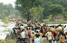
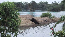
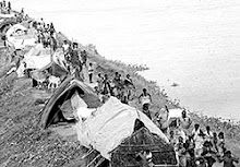
The Kosi embankment was breached near the Kusaha village in Nepal on August 18, 2008 turning four Panchayats of Nepal: Western Kusaha, Sripur, Haripur and Laukahi with a population of nearly 35,000 in to a watery graveyard. The flood-affected districts in Bihar include Supaul, Saharsa, Araria, Purnea, Katihar, Madhepura, Khagaria and parts of Bhagalpur. Following the breach, the water is flowing through three of the some 15 old streams of the Kosi river, namely Sursar, Mirchaiya and Belhi.
Approximately 85 per cent of some 1.5 lakh cubic feet per second (cusecs) of Kosi water is flowing through the breach in the embankment. Initially, the breach was quite small-just few metres-wide- on the eastern side, 12.9 km upstream of the Bhimnagar barrage in the afternoon of August 18 now it has widened to more than two km now, destroying standing crops and flattening houses coming on its way. It is noteworthy that the embankment and the barrage were designed to resist 9.5 lakh cusecs of water flow but it could not resist the flow of water, which was about 1.44 lakh cusecs. Given the fact that the river is embanked at least 135 km downstream from the site of the breach, the water flow was compelled to go into the old Kosi streams.
The embankment repair work, which was the responsibility of India, should have been competed before June, 2008 and at least by the first week of August 2008 based on vulnerability assessment. However, the immediate concern seems to be removal of the impediments in the drainage of this water into the Kosi river at Kursela. Meanwhile, While the magnitude of death, destruction and damage is yet to ascertained properly due to the inaccessibility of the flood affected areas, reports that require further corroboration suggest that some 80 people have died due to the floods and some 5000 people have been washed away.
Although the new Nepali Prime Minister has called the Indo-Nepal 1954 Kosi treaty that led to construction of embankments a “historic blunder”, while terming the floods as a “national calamity” Indian Prime Minister and the Bihar Chief Minister remain votaries of embankments, dams and now desilting as effective flood control measures despite the fact that the former has life span of 25 years and the latter has a life span of 37 years. As to desilting, one is yet to witness any “credible agency” present a rational and reasonable method of desilting Kosi river that brings 5 crore 50 lakh tones of silt every year after the experience of having desilted Eastern Kosi Main Canal.
A technocracy that is caught in time warp has clearly failed in its misplaced attempt to tame the river by not acknowledging that Kosi is most violent and unstable river of the world. Over the last 250 years, the Kosi River has shifted its course over 160 kilometres from east to west. Continued and sustained support for a totalitarian science of embankments has failed, not once or twice but eight times till date.
No political party both within the state and at the center can be absolved of acts of omission and commission that has brought perennial misery to North Bihar because their policy decisions have contributed to it. Having invented lame excuses umpteen times, the politicians and acolytes of all hues are now arguing that the river has changed its course and it now wants to move to east. In the absence of even an iota of accountability towards criminal neglect, the million dollar question posed by flood experts that remains unanswered is: why was the embankments constructed along the river? Weren’t they supposed to prevent the river from moving either east or west? Did the Water Resources Department know that the river wanted to change its course? Is Central Water Commission relevant anymore? Why did it help the river accomplishing its objectives?
While answers to all embankment failures demonstrate the irrelevance of such structural measures, floods have hit nearly 35 lakh people. Relief operations that are underway have no meaning unless marooned people are accessed. All rescue efforts must acknowledge that the worst is yet to come because a major food, public health and waterlogging crisis is on the anvil. It is heartrending to note the indifferent manner in which flood victims are being provided uncooked food and lack of planning for shelter, fuel, fodder, medicines, hygiene etc, requires immediate self-correction. Huge percentages of flood and embankment victims are without any external assistance for more than two weeks so far. All endeavors must be both short-term as well as long term that addresses crying concerns that go beyond the exigencies of the upcoming parliamentary elections.
Embankments have breached, it’s breaching and it would breach again. Law of unintended consequences is clearly at work.
By Gopal Krishna
Countercurrents.org
Author was a member of the Fact Finding Team that visited flood affected parts of North Bihar & Nepal
Subscribe to:
Post Comments (Atom)


No comments:
Post a Comment