Note: Dr Dinesh Kumar Mishra, arguably one of the very few most-competent technocrats/scientists on river system and flood patterns in Bihar, wrote an incisive article on Kosi flood in EPW. It is reproducedd here. To see the map, kindly click the URL. (http://www.epw.in/uploads/articles/12619.pdf)
Sankar Ray
Bihar Floods: the Inevitable Has Happened
By Dinesh Kumar Mishra
The overflowing Kosi had, as of end-August, wreaked destruction on more than three million people living in north and east Bihar. A field visit reports on the misery of the affected, haphazard rescue efforts and criminal exploitation of the uprooted. The immediate task is to improve relief operations and then provide support to the displaced who will not be able to find work until the 2009 kharif season. A blame game is now in operation, but since the early 1960s whichever the party in power, the people of Bihar have been affected by official apathy towards the embankments on the Kosi. This time it is a clear case of dereliction of duty by the state government in repairing upstream barrages before the monsoon of 2008 that has resulted in devastation.
A ugust 5, 2008. At a meeting organised by a non-governmental organisation in Patna, the minister for disaster management of Bihar was enumerating the steps taken by the government of Bihar to meet any disaster and the roles that all concerned had to play in the event of a disaster.
Little did the minister know that a disaster was brewing some 300 km north of the venue of the meeting, on the banks of the Kosi. I got an opportunity to ask the organisers why the minister for water resources was not invited for the discussions as most of the disasters faced in Bihar are water-related, whether of scarcity or abundance. Nobody had the answer as the simplistic understanding is that disasters are independent of their surroundings. This may be true of earthquakes but not of floods or droughts that are water-related and the presence of water resources personnel would have added value to the meeting on disasters. That, however, rarely happens as both the departments of the government of Bihar work independently of each other for reasons unknown.
Geography of the Kosi
The Kosi, one of the most vibrant rivers of north Bihar, starts its journey at a height of about 7,000 m in the Himalayan range and its upper catchment is located in Nepal and Tibet. The river is also called the Sapta (seven) Kosi in Nepal, because of its seven tributaries (the Indravati, Sun Kosi or Bhot Kosi, Tamba Kosi, Likshu Kosi, Doodh Kosi, Arun Kosi, and the Tamar Kosi). The first five tributaries join to form the Sun Kosi that flows from west to east. The Sun Kosi, Arun Kosi and Tamar Kosi join at Triveni in Dhankutta district of Nepal and assume the names Sapta Kosi, Maha Kosi or the Kosi. Triveni is located in the hills, about 10 km north of Chatra, where the river descends onto the plains.
After entering the plains, the bed of the Kosi widens drastically and it spreads over 6 to 10 km. After traversing a distance of about 50 km in Nepal, the river enters India at Bhimnagar. Hanuman Nagar, located on the west bank of the Kosi, is in Nepal while Bhimnagar is on the east bank, in the Bihar district of Supaul. From Bhimnagar the river flows in a southwesterly direction for about 100 km till it reaches Mahishi in Saharsa district. From Mahishi, it turns south-east and after flowing another 33 km, it crosses the Saharsa-Mansi rail line, south of Kopadia railway station, and joins the Ganga near Kursela in Katihar district. The total catchment area of the Kosi is 74,030 sq km, excluding the catchment areas of its two important tributaries, the Kamla (7,232 sq km) and the Bagmati (14,384 sq km). These tributaries of the Kosi are important in themselves and are generally dealt with separately. Out of the total catchment of the Kosi, only 11,410 sq km are located in India and the rest (62,620 sq km) lie in Nepal and Tibet. The river's catchment area at Triveni in Nepal is 59,550 sq km. The average rainfall in the upper catchment of the Kosi is 1,589 mm while in the lower areas it is 1,323 mm. The average annual silt load of the river is 92,400 acre feet. Due to its high sediment load, the river is known to meander and has shifted course by about 160 km between 1723 and 1948. It was flowing east of Purnea in 1731 and its last course that was embanked in the 1950s was west of Saharsa and east of Darbhanga. Between these two points there is not an inch of land through which the Kosi has not once flowed. It has 15 abandoned channels through which its water used to flow before embanking.
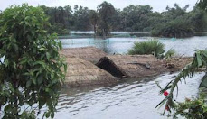
After a century long debate against embanking the river during the British period, the Kosi finally fell prey to the embankment builders in the late 1950s. As a result, a barrage in 1963 was constructed at Bhimnagar to regulate the flow of the river to facilitate irrigation of 7,12,000 ha, through the Eastern Kosi Main Canal.
Another canal, called the Western Kosi Canal, the foundation stone of which was laid in 1957, is also being constructed to irrigate some 3,25,000 ha of crop land on the western side of the barrage. The work on this canal is still in progress. A 125 km long embankment was built on the eastern bank of the Kosi, from Birpur to Kopadia and another 126 km long, from Bhardah in Nepal to Ghonghepur in Saharsa, on the
western bank. This work was almost completed by 1959. The embankments were designed for an ultimate discharge of 9,50,000 cusecs and were supposed to protect 2,14,000 ha of land from the recurring floods of the Kosi. As an extension of the eastern embankment, a 34 km long embankment was constructed in Nepal to protect the areas there together with a 12 km long afflux on the western side of the river in Nepal. It is this eastern afflux bundh in Nepal that has breached this year at Kusaha, 12 km north of Bhimnagar. The responsibility of maintaining these bundhs is vested with the water resources department of Bihar.
Kusaha Breach
Let us now move to the village Kusaha in Nepal on the eastern afflux bundh of the Kosi. There two spurs were constructed at 12.1 km and 12.9 km (from the Bhimnagar Barrage), the former 200 m long and the latter 269 m long. The river meandering between the two embankments of the Kosi came so close to the spurs that it started eroding the one at 12.9 km. That was on August 5 this year. Slowly the river touched the spur at 12.1 km also and now both the spurs were under the attack of the river. Erosion of the embankments meant that the embankment would be directly attacked by the river and it would be totally defenceless and could breach to the detriment of the people living on the countryside of the embankment. The river continued gnawing at the embankment and the inevitable happened on August 18.
Thus, there was almost a fortnight�s time available to take precautionary measures and that time was squandered. The story that is now floating around suggests that the two Indian contractors allotted the work of repairs in Nepal near the breach site were obstructed by the local Nepali population who were demanding employment. It is also suggested that some of the local people might have been demanding extortion money and favours from the contractors.
There was some impediment created by the Nepalese army camp through which the trucks carrying boulders and other building materials had to move. Local people suggest that there is some truth in this story but that is not the whole truth. Had the contracts been given to Nepali contractors, they would have been in a better position to handle the situation such as in dealing with the labourers and, possibly, with the army. Their concern for the wellbeing of the local population would have been an added incentive to them as any laxity in the work would result in a disaster and Nepal would be the first victim.
What, however, did not happen was that the Nepal government should have been but was not taken into confidence to take care of the law and order problem, if there was any, at the site and on the access road to it. Official channels through the government of Bihar, the government of India, the Indian embassy in Kathmandu, and the ministry of external affairs, were all available to deal with other impediments and a fortnight�s time was not short for the purpose. According to an eminent activist who works on water issues, Ajaya Dixit of Nepal, the relations between India and Nepal had been very cordial in the past two years and it was not difficult for the government of India to convince Nepal of the dangers on the eastern afflux bundh. Only an inquiry will reveal whether or not these efforts were made. It would also be too simplistic to say that the problem cropped up only on August 5.
Dereliction of Duty
There is a set procedure to keep the embankments and the river in their respective positions and the process starts with a visit to the area by the Technical Advisory Committee (TAC). The TAC consists of engineers from the Central Water Commission (CWC), the Ganga Flood Control Commission (GFCC) and the water resources department (WRD) of Bihar who meet in February every year. The TAC recommends precautionary measures to save the embankments, the estimates are prepared based on these recommendations and the work taken up is to be completed by June 15. A field emergency in the month of August smacks of irregularity in completion of the work on time and the afflux bundh was allowed to breach. A clear case Every district in Bihar has flooded to some degree at one time or another. No district can claim to be flood free of dereliction of duty has led to destitution of millions of poor Bihari families and demands trial of the persons guilty of the offence in a court of law.
As a result of the breach, the river surged from the break point and hit the panchayats of Kusaha, Sripur, Haripur, and Laukahi in Nepal, then breached the east-west highway in Nepal that connects Viratnagar to Kathmandu, besides uprooting a population of about 35,000 in the country. It is reported that the breach
occurred at a discharge of about 1,44,000 cusecs in the river and that after the event only 10-15 per cent of the flowing water was left for the original river within the embankments and the rest is now flowing outside, engulfing the districts of Supaul, Madhepura, Araria, Purnea, Katihar, Saharsa and Khagaria. Since at the time of writing (end August) the rainy season is not yet over, the water reaching the breach spot is varying all the time and so is the flood level in the immediate vicinity. It is important to note that the maximum river discharge of 9,13,000 cusecs was observed on October 5, 1968 and one fears that even if half or one-third of that volume reaches Kusaha, the miseries of the people would be increased manifold.
A small laxity in the maintenance of the mbankment has become a major catastrophe for the people and the floods that used to sneak in like a cat are this year roaring like a tiger.
End august Position
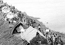
At the time of writing this report (August 31), 16 districts, 98 blocks, 1,704 villages, and 30.65 lakh persons are reported to be hit by the floods mainly in the districts of Supaul, Araria, Purnea, Katihar, Madhepura and Khagaria, where the Kosi waters have spread almost all over. There have been 56 human deaths and crop area worth 1.09 lakh hectares has been hit by the floods. Some 2,83,797 houses are reported to have been damaged. The government has deployed 2,036 boats to rescue people and 182 relief camps have been opened to lodge 1,14,278 persons so far. Apart from distributing 4,455 quintals of wheat/rice/ chana/chura and sattuu, the state government has also distributed 63,268 polythene sheets. Obviously, the government has not been able to reach most of the flood victims or else there is something
missing with its reporting system. A visit to the area reveals the anger and frustration of the people and the irony is that the minister of water resources, and the minister of disaster management and the secretary of the disaster management department, all belong to Supaul, one of the worst hit districts. Looking at the
western Kusaha village or the slumped bridge on Nepal�s east-west highway was a pathetic sight. There were residents of Kusaha on the afflux bundh who were pointing towards where their houses were in the village and what was left there. That was on August 24. A young boy was sobbing that he last heard from his sister on August 19 through a mobile call and did not know whether she was still alive.
A team of the members of Barh Mukti Abhiyan, an informal group of citizens of Bihar concerned about the flood issue tried to unsuccessfully enter Birpur town on August 25 and had to contend with taking a trip to 22 RD (1 RD equals 1,000 ft) from the headwork of the Eastern Kosi Main Canal where the gushing waters from Kusaha had breached the canal. Part of the water there was diverted into the canal that was flowing to its full supply depth and a part was going south. Local villagers and officials were trying to prevent a further widening of the breach. We were told here that another breach had occurred in the canal at 36 and 43 RD. We tried to walk down to 36 RD (about 4.5 km further down) but it was an ordeal as one had to either wade through the water collected along the canal or negotiate the route by walking on sand that was dug out of the canal and dumped aside. On the way, we met some jawans who advised us to go back as it may not be safe to move further as the canal may breach any time and it will take long hours to travel that far walking through sand and it would be dark before one could return. We listened to this warning and returned.
We met Sunil Bharti, a young man in his 20s who was trying to reach his village Balua to find his marooned family and had hired a boat paying Rs 4,000. He had gone up to 54 RD where he was chased by gangs who overpowered him and the boat man and snatched the boat. He returned after paying another Rs 500 to another boat man for crossing a stream and was walking back having lost all that he possessed.
We also met many men and women who kept asking us where they should be going to spend the night.
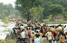
War-like exodus
It was a war-like exodus as one reached the road connecting Simrahi with Pratapgunj
district in Supaul district and settlements had come up along the road all over. The people were fleeing from their villages via the rail line connecting Raghopur with Forbesgunj. The latecomers had to travel a longer distance on the Simrahi road to even find space to put themselves down on the road. They had to flee from their homes as the water flowing out of the breach in the canal had entered Sursar, Mirchaiya and Belhi channels of the Kosi which it had abandoned long ago. These channels were full of water this year and the exodus of the people was the obvious corollary. At Simrahi Chowk we saw many persons asking for the direction to go to the Raghopur railway station for that was the right place to spend the night and if there was any train available, they wanted to go to a destination where the floods would not follow them.
In Kursela, a car of the information department of the government of Bihar was going around making an announcement on August 26 that there was danger of water hitting the blocks of Barari, Falka, Sameli and Kursela and advising people to move to safer places. What were the safer places was not the part of the announcement. There was no panic, however, but the blocks are now facing inundation.
The worst sight we saw was in Phulkaha block of Araria district. The road connecting Bathnaha with Phulkaha acts as a wedge in the water and settlements have come up near Phulkaha. A large number of people were looking for their dear ones in the boats that were coming from where the Sursar had breached its embankments. There were only a few boats and this had prompted the administration to rescue only women from the marooned areas. The women coming out complained that this order was followed literally and that the children and infirm elders had been left behind. To cap it all, they also reported that the boatmen and the accompanying policemen asked them for money and even ornaments and threatend to drown them mid-stream if they did not comply. The police and officials had even threatened to molest the women and the situation was quite tense when we were there on August 27. There were, however, two relief camps in Phulkaha and medical facilities were available to the flood victims although the number of persons needing such help was very large.
Inaccessibility is the real problem and arrangements are needed to either rescue the people and take them to relief camps or reach relief to them wherever they are. That can be achieved only by increasing the number of boats and helicopters. It is intriguing that the government is shying away from deploying helicopters. It
had deployed 13 helicopters during the floods of 1987 and 11 in 2004. There is no reason why they should be content with using only three this time. The number of boats is incredibly small compared to the number of persons needing evacuation. No relief operation worth its name is possible unless people are reached. The only good thing is that neighbouring villages that are dry have come to the rescue of the marooned people with whatever food, fodder, clothes, etc, they could carry to the places where people have been stranded. Even these people could not get boats to travel into the flooded areas.
Shortage of Boats
The situation continues to be chaotic as there is nobody to coordinate whatever relief is possible. Boats, at the moment, are the prime need. Other things will follow. With the kharif crop washed away and with little chances of rabi operations being taken up, the employment position is going to be grim for the entire crop season this year. This will lead to a mass exodus of people in search of work. Also, it will only be after the water recedes that one would come to know of how much agricultural land has been sand cast and how much has been lost to waterlogging for which the only remedy is either evaporation or seepage of the water into the ground.
Blame Game
There is another drama, so common in such incidents, that is being enacted to escape responsibility for the disaster. After blaming Nepal and the Nepali people of non-cooperation, the engineers and their political masters in Bihar have started saying that the river has changed its course and it now wants to move to east. If that is true, why on earth were embankments constructed along the river? Were they not meant to prevent the river from moving either east or west? How did the department of water resources know that the river wanted to change its course? Why did it help the river in accomplishing its objectives?
Did the engineers and politicians not say earlier that the river was trying to move to west in case of breaches at Dalwa, Jamalpur and Joginia? Who will be responsible for the damage to life and property that has been caused by the negligence of a few? Every leader worth his salt and his party has blamed the government of Bihar for the disaster which they call is the worst ever tragedy.
History of Breaches
But does anyone remember that this is the eighth incident of its kind and that the first breach in the embankment had occurred in 1963 near Dalwa in Nepal, much before the Kosi project was completed.
Binodanand Jha of Congress was the chief minister then and the responsibility of the breach was at that time placed on the rats and foxes that had dug holes in the body of the embankments through which water had seeped and they had breached! The second incident took place in 1968 near Jamalpur in Darbhanga when five breaches occurred in October. Engineer P N Kumra of CWC had conducted an inquiry and had once again identified the rats and foxes as the culprits. The state was then under president�s rule. The third incident occurred at Bhatania in 1971 when the approach bundh collapsed between the 10th and 19th km below Bhimnagar, and many villages were washed away but the eastern embankment had not breached. Since only eight villages were affected, the incident did not get wide publicity. The next incident occurred in 1980 near Bahuarawa in Salkhua block of Saharsa district near the 121 km mark below Bhimnagar. The river eroded the embankment but just after the breach, it receded very quickly and the water did not spill on to the countryside.
The state was at the time ruled by Jagannath Mishra of the Congress Party. In 1984, a tragedy as terrible as Jamalpur struck the eastern embankment near Hempur village in the Navhatta block of Saharsa district, 75 km below the Bhimnagar barrage. The floods uprooted half a million people and engulfed 96 villages in Saharsa and Supaul districts. People could go back to their villages only after the Holi festival of 1985 when the breach was plugged. Bindeshwari Dubey of the Congress was the chief minister that year.
In 1991, there was a breach in the western embankment near Joginia in Nepal that led to a political crisis in Bihar and the minister of water resources had to resign his post. This resignation was never accepted by Lalu Prasad Yadav who was the chief minister at the time. This was a repeat of the Bahuarawa breach where the river had receded after eroding the embankment. The Kusaha breach took place in the regime of Nitish Kumar and it will take about a year to get the complete story. Thus, virtually no ruling party (including the administration under president�s rule) can claim that it was not involved in such an accident. Yet, the blame game and mud-slinging continues unabated. There is no history of these breaches being plugged before March
of the following year.
As far as the flood victims are concerned, they bear the brunt of the disaster, irrespective of which party is in government. It is also a fact that the breaching of the embankments will continue in future in full view of the political parties, the water resources department, police, and the administration. Given the magnitude of the disaster, in all probability the flood victims will be left to fend for themselves.
All these debates notwithstanding, the need now is to reach help to the flood victims in all possible ways and provide them support until the next kharif crop season.
Dinesh Kumar Mishra (dkmishra108@gmail.com) has been working on water-related issues in Bihar for many years and is the convenor of the Barh Mukti Abhiyan, a civil society organisation working with people living in flood-prone areas in the region.
Subscribe to:
Post Comments (Atom)


No comments:
Post a Comment